This map records the LTNs in Camden. The ‘historical’ ones such as the Primrose Hill and Argyle Square areas which date from the ’60s and ’70s are shown as purple areas*. The recent ones (from 2019 on) are shown as blue areas and those under consultation as orange areas. The areas are given in hectares (1 sq km = 100 hectares). The landscape areas such as Hampstead Heath are part of the underlying map – only the largest ones are shown.
* These include two ‘fortuitous’ LTNs – areas that are naturally traffic-free (Parliament Hill and Millfield Lane)
Each area has a pin associated with it. The pins provide access to the information collected, which includes the name, the ward it’s in, its area, the date the scheme was completed (for recent schemes), a description of the types of closures used and some photos.
Larger Map. The Google Sheet on which it is based is here. And for people who can’t access Google Docs, a PDF is here.
The interactive chart below shows the total area of LTNs built each year. (It is based on the chart in the Google Sheet). Roll the cursor over the data points to see the areas in hectares.
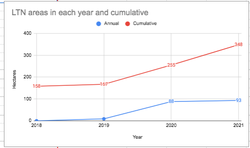
The figure for 2018 is the sum of the historical areas. Note that the area of the seven major parks (Hampstead Heath, Primrose Hill and Regent’s Park east of the Broadwalk, Waterlow Park, Highgate Cemetery, St Pancras Gardens and Corams Fields) is 318 hectares, while the area of Camden is 2176 hectares.
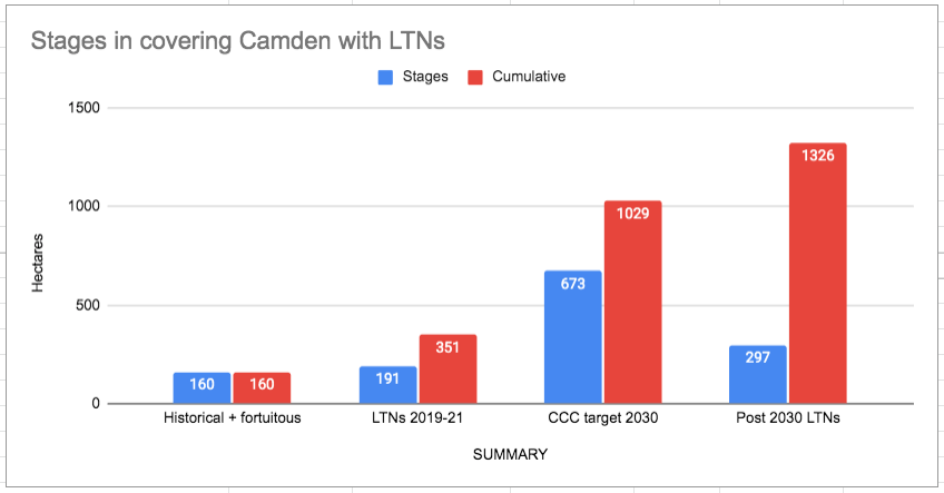
Targets for progress with LTNs
As part of LCC’s new Climate Safe Streets campaign, we have made a map showing how LTNs and protected cycle routes can be combined so that everybody in the borough will live within 200 m of either a protected cycle route or an LTN. The map is here