Camden Council
The Transport Strategy was reviewed and targets updated in 2022, See here
The Transport Strategy 2018-41 was adopted on 8th April 2019
Cycling Action Plan Walking Action Plan Road Safety Action Plan Electric Vehicle Action Plan
Consultation and decision-making processes
November 2021. See this page
Mayor and TfL
Road Safety Data TfL including the Road Danger Reduction Dashboard
Mayor’s Transport Strategy 2018 (MTS)
Strategic Cycling Analysis (SCA)
Healthy Streets this page includes links to the Healthy Streets Indicators and the Healthy Streets Check
The maps in the MTS and the SCA can be viewed here.
Cycle infrastructure design (LTN 1/20)
This guidance for local authorities on designing high-quality, safe cycle infrastructure was published
27 July 2020 by the Department for Transport and can be downloaded from here
London Cycle Design Standards (LCDS)
The seven chapters can be downloaded from the Streets Toolkit page
Chapter 2 – tools and techniques is here. This includes CLoS – Cycling Level of Service assessment matrix in Fig 2.3 ( pages 6-10)
Chapter 4 – Cycle lanes and tracks is here. This includes some diagrams useful when arguing about cycle track widths e.g.
- LCDS Figure 4.12 page 52 relates cycle flows (‘Low’, ‘Medium’ and ‘High’) to the recommended widths for one-way tracks and two-way tracks.
- while LCDS Figure 4.12b page 54 defines the meaning of ‘Low’, ‘Medium’ and ‘High’
Junction Assessment Tool
See LTN 1/20 Appendix B (also in LCDS Section 2.2.7 (page 13).
This provides a neat way of giving a score to a junction.
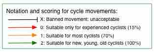
On each arm of the junction, consider each possible movement (at a crossroads there should be three) and for each one score as 0, 1 or 2. E.g.
- a movement that proceeds from one protected lane to another and is protected in time across the junction will score 2.
- while a left hook or unsupported right turn (i.e having to wait in the middle of the road) will score 0
Examples:
- see how we used JAT to assess the design for the new implementation of the Theobalds Road/Southampton Row junction
- and this map shows junctions on the cycle network some of which we have assessed
- here is one that we did for the junction of Pancras Road and Midland Road JAT Pancras Midland with signals
- and another at Cobden_assessment
- and another at the junction of Kentish Town Road and Fortess Road KTR-Fortess-JAT score
DfT
Traffic Signs Manual. TSRGD.


