
Several recent TfL reports include static images representing mapped data. To make them more useful I have produced scalable interactive maps with the map images from the relevant reports overlaid. You can view the maps at the links below and use the small slider at the top-right of the main map to vary the transparency of the overlay. The legends are normally in the bottom left corner of the overlays.
Maps from the figures in Streetspace for London, May 2020
-
-
Emerging London Streetspace Plan for Cycle Routes (Map), 15 May 2020 (legend bottom right)
-
From Appendix Four: Analysis on Temporary Strategic Cycle Network (download the document here):
(Legends are bottom left, sometimes a little obscured by the underlying maps)
-
Figure 4.4: Temporary Strategic Cycling Analysis for Streetspace Plan
-
Figure 4.5: Temporary Strategic Cycling Analysis: borough and TLRN corridors
-
Figure 4.6: Temporary Strategic Cycling Analysis compared to carriageway widths
-
Figure 4.7: London’s strategic freight network
From Appendix 6, 6a & 6b: Analysis on Low Traffic Neighbourhoods:
(Legends are bottom right, sometimes a little obscured by the underlying maps, registration with roads may not be as good as on the other overlays)
From Appendices 6a and 6b Strategic Neighbourhood Analysis V1 .0 June 2020 (download the document here):
From the original Appendix 6 (now superseded by V1.0 above):
-
-
Figure 4.8: Flatted accommodation access to green space (high resolution)
-
Figure 4.9: LTN areas for further investigation (high resolution)
-
Figure 4.10: Potential LTN access to green space(high resolution)
-
Figure 4.11: Potential LTNs with local and connector bus routes (high resolution)
-
London Borough of Camden maps
-
Covid-19 Pop-up cycle lanes: from Making travel safer in Camden
-
LB Camden roads hierarchy: Figure 2.3 from the Camden Transport Strategy
Maps from the figures in TfL’s strategic Cycling Analysis (SCA), June 2017
[Download the TfL document (PDF 6MB)]Figure 1: Current plan for cycling routes – according to the TfL Business Plan
Figure 1.1: Roads and paths hosting the highest current cycle flows 
Figure 1.2: Roads and paths hosting the highest potential cycle demand
Figure 1.3: Existing and planned cycle infrastructure with current and potential cycle demand
Figure 2.1: Categorisation of current cycle demand
Figure 2.2: Categorisation of potential cycle demand with high propensity to cycle areas
Figure 2.3: Categorisation of population and employment growth
Figure 2.4: Prioritised Strategic Cycling Connections
Figure 3.1: Potential to improve pedestrian environment
Figure 3.2: Potential to improve road safety for people walking and cycling
Figure 3.3: The SCA and high bus frequency
Figure 3.4: The most important transport hubs for cycle interchange
Figure 3.5: The potential for a cycling network to improve access to public transport
Figure 4.2: Area-wide opportunities to expand cycling connections
Figure 5.1: Top Potential Connections recommended for further study
(Figure 5.1: Top Potential Connections (as above with white background) )
Relevant maps from the Draft Mayor’s Transport Strategy June 2017
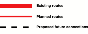
Figure 4: Opportunities to Improve the Cycling Network in London
Figure 4 Legend:
Figure 22: Shaping and Growing the Bus Network
Overlays of some of the above maps in pairs
MTS Figure 22 Shaping and Growing the Bus Network over SCA Figure 5.1 Top Potential Connections
SCA Figure 5.1 Top Potential Connections over SCA Figure 4.2 Area-wide Opportunities
Existing LTNs versus TfL’s Analysis of Opportunities – On a separate page with explanation
Method used to produce the pairwise overlay maps:
Use MapTiler to make separate tilesets for each layer, use Javascript in the index.html to combine them, with sliders to vary opacity of each. Examine one of the index.html files for for details of the code.
Proposed City of London Cycling Network
-
Interactive version of the CoL map
-
The City of London Transport Strategy (adopted May 2019) includes a proposed cycling network for implementation in phases over the period 2020-2035. This interactive map is based on the static map pubished in the City of London Transport Strategy Map Pack (November 2018).
-
Static map of the SCA Figure 5.1 Top Potential Connections over the CoL cycle network map (PDF file)
Method used to make the SCA and MTS maps:
- Use Adobe Acrobat Reader or Pro to select a figure in the TfL report as an image and save it as a PNG (preferable) or JPG file
- Use the MapTiler application to prepare the overlaid map:
- register the image with the Google/OSM map by choosing 4 common ‘anchor points’
- render the tiles (at zoom levels 8 to 14) in a local directory
- upload each rendered directory of map overlays to a separate directory at https://camdencyclists.org.uk/tfl-SCA-maptiles
George Coulouris
28-7-2017 (Updated 18-3-2021)