
The alignment of this route
TfL has installed signage along a cycle route between Euston Station and High Holborn. This route follows Phoenix Road, Midland Road, Judd Street, Hunter Street and Lamb’s Conduit Street and Red Lion Street.
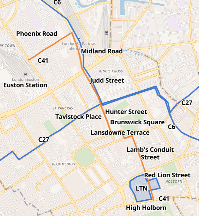
You can see this route in the context of TfL’s cycle route map.
We will show examples of two signs and then describe the many recent changes that have improved this route.
Examples of some signs

The sign on the right has C41 at the top! Then C6 which is currently signed as far as Kentish Town – but you can cycle on via Prince of Wales Road to Haverstock Hill. The C27 route heads west towards Westminster via Tavistock Place, or east via Calthorpe Street through Islington and Hackney. The C6 also heads east and then south down Farringdon Road and on to Elephant and Castle.

Recent changes
C6 route through Midland Road and closure of Judd Street


In 2019 TfL agreed to implement a design for a safe cycle crossing over Euston Road between Midland Road and Judd Street. With-flow and contraflow protected cycle lanes were installed on Midland Road. The northern end of Judd Street was closed to motor vehicles. Before this, southbound cycling on the one-way Midland Road was very hazardous. See StreetView from 2018
Brunswick Square


A radical scheme completed in 2019 returned space to pedestrians by removing a roundabout and closing Lansdowne Terrace to motor vehicles. See how it was on StreetView
Lamb’s Conduit Street


About 20 years ago, Camden Council closed the middle section of Lamb’s Conduit Street to motor vehicles apart from loading (one way northbound). The footways were widened and two-way cycling was retained. Have a look on StreetView to see how it was in 2008 when signage didn’t permit “No Entry Except Cycles”
Red Lion Street Low Traffic Neighbourhood

Photo 9 (from 2015) shows how difficult it was to use Red Lion Street as a cycle route in the rush hour. By July 2020, Red Lion Street, Princeton Street and Dane Street were closed to through traffic. The new trees were planted in 2022.

Phoenix Road


Phoenix Road plus Brill Place (at the eastern end) runs through Somerstown. In preparation for the 2012 Olympics, some improvements were made and it was signed as a walking (and cycling) route between Kings Cross/ St Pancras and Euston Station. More recently, Camden has used HS2 funding to ‘green’ the route as well as make other improvements in Somerstown.
A couple of problems
This route is effectively a secret unless you are already on it: there is no sign on either High Holborn or on Eversholt Street indicating its presence. See photo 13 as an example. A former route on this alignment between Kings Cross and High Holborn was signed in 2012. The original signs are mostly still in place and are generally helpful


However, we have found one place where the signs are contradictory: the nearer sign in photo 14 advises a left turn for Euston (via the Somerstown route) while the further sign (also visible in photo 15) advises straight on.

Summary
We have reminded readers how the very bold Midland–Judd scheme extended the C6 route across Euston Road and vastly reduced the motor traffic flow in Judd Street. This was followed up by the public realm scheme for Brunswick Square which reduced the motor traffic significantly in Huntley Street and almost to zero in Lansdowne Terrace. The low-traffic neighbourhood in the Red Lion Street area formed the finishing touch.
The C41 route is a good example of how a cycle route can be constructed from a variety of components:
- protected cycle lanes on a busy street (e.g. Midland Road)
- quiet streets within an LTN (e.g. Red Lion Street)
- crossings over barriers (e.g. over Euston Road)
And that ‘greening’ can vastly improve the feeling of a cycle route, for example, in Phoenix Road, Brunswick Square and Red Lion Street