
News from the Streets Dec 2025
News from the Streets May 2025
News from the Streets Sept 2024
News from the Streets May 2024
News from the Streets March 2024
News from the Streets February 2024
Click on any image to see an enlargement
Progress on major projects under construction
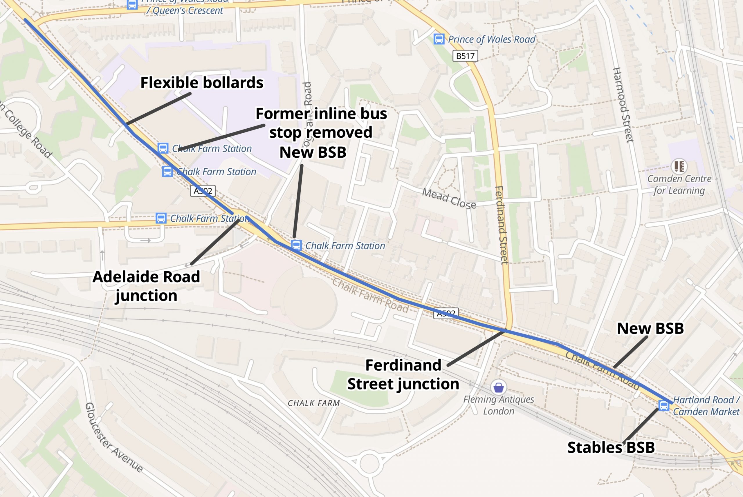
Chalk Farm Road completed
The temporary scheme with flexible bollards was completed by April 2021; it ran from a little north of the junction with Castlehaven Road to the junction with Prince of Wales Road. It included an important improvement at the junction of Ferdinand Street – Juniper Crescent (allowing cycling straight across). It also included four new bus stop bypasses, one opposite Haverstock School and three cunningly fitted into the fairly narrow Chalk Farm Road.
The permanent scheme includes a major upgrade to the junction with Adelaide Road as well as the replacement of the lanes protected by flexible bollards with stepped tracks. The inline bus stop outside Haverstock School has been replaced by a bus stop bypass near to Crogsland Road and a new bus stop bypass near Hartland Road has been added.


Junction at Adelaide Road – Haverstock Hill – Chalk Farm Road – Crogsland Road – Regents Park Road
There are three major approaches to this junction (from Adelaide Road, from Haverstock Hill and from Chalk Farm Road). The signalling has been designed so that cycles can make their manoeuvres across the junction without risk of collision with other vehicles.
Adelaide Road approach: cycles are in their own protected lane with their own dedicated signal stage. The photo on the left shows the cycle signal on green and the motors on red so cycles can safely turn left into Haverstock Hill or right into Chalk Farm Road. Note that this is different from early release where cycles and motors both have a green signal after the first few seconds (as for example at the Ferdinand Street junction).


Haverstock Hill approach. These photos show the southbound approach on Haverstock Hill where cycles and motors have their green and red signals at the same time. Both the photos show “Ahead Only” on the cycle signal head and any thought of turning right is discouraged by the protective kerb that runs down as far as the pedestrian crossing.


Questions: Why isn’t there any safe and convenient way for cycles to turn into Adelaide Road? Why can’t the cycle signal stay on green during the next stage when the motor vehicles are coming out of Adelaide Road?
The pedestrian crossing at the middle of the junction.

The very substantial kerb protects cyclists continuing southbound from Haverstock Hill. The pedestrian crossing is immediately ahead of the nearest set of signals in the photo. Beyond the crossing, Crogsland Road is on the left and Regent’s Park Road on the right (see the third right turn lane – on the other side of the crossing). The pedestrian all-green signal stage allows people to cross here or over Adelaide Road and Haverstock Hill.
Motor traffic heading for Adelaide Road will use one of the right turn lanes this side of the crossing.
Another question: how do cycles turn right into Regent’s Park Road? Note that the alignment on Crogsland Road–Regent’s Park Road is shown as a C-link on TfL’s map of Camden Cycleways
Crogsland Road and Regents Park Road


Crogsland Road is one way out with contraflow cycling; cycles entering or leaving the junction use the two-way kerb-protected lane on the right (as has been the case for time immemorial), Regent’s Park Road is one way in for motors with contraflow cycles now moved to the left side (where they should be).
Chalk Farm Road (northbound) approach: on this approach a cycle gate is used in a very original way: the reservoir includes the junctions at Crogsland Road and Regent’s Park Road. When the northbound cycles have a green signal they can enter the reservoir and head left, right or straight to the front stop line with the red signal (Fig 1).
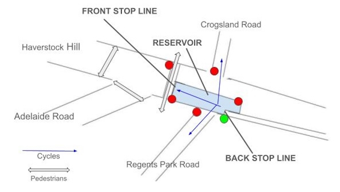
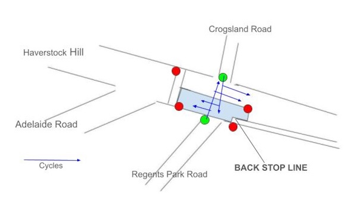
We have described cycle gates in earlier issues e.g. see here for examples at Judd Street and Procter Street. In those examples, the motor traffic is released from behind only a few seconds later than the cyclists. But here, the all-green pedestrian stage happens at the same time (Fig 1). After that, the cycle signal at the back stop line turns red and motors are still held back while cycles are released from Crogsland Road and Regent’s Park Road (Fig 2)** .
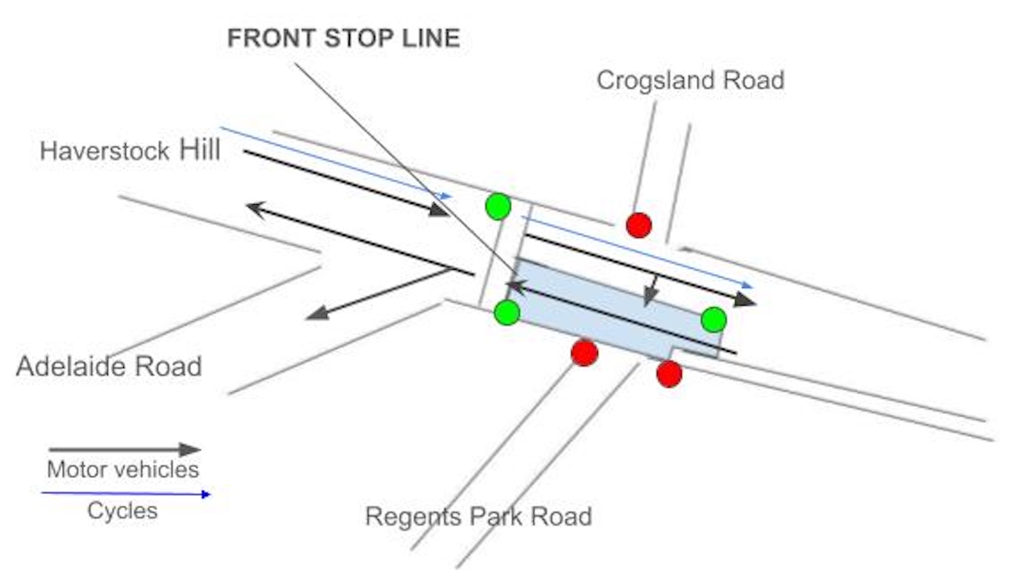
During the next stage (Fig 3) the signals at the front stop line and the motor (back) stop line are green. The cycles waiting at the front stop line should be well into Adelaide Road or past the Adelaide Road junction before the motors catch up with them. This may seem a long wait for the cyclists at the front stop line, but they won’t need to wait any longer than the drivers behind them. Note that cyclists at the back stop line have a red signal to prevent them from mixing with the motor traffic.
The southbound traffic from Haverstock Hill also runs in this stage of the signals. The motors can turn right into Regent’s Park Road. We haven’t shown a right arrow for southbound cycles in Fig 3: Question: to repeat our above question, how do cycles turn right into Regent’s Park Road?
Finally, the northbound traffic on Chalk Farm Road and the southbound traffic on Haverstock Hill get red signals so that motor vehicles can be released from Adelaide Road. To complete the story we can reveal that cycles get the green signal on Adelaide Road at the same time as Crogsland Road and Regent’s Park Road.
** After the cycle signal turns red, a few seconds are added to the all-green stage to allow for pedestrians to cross over Regent’s Park Road.

The signalling has been designed so that cycles can make their manoeuvres across the junction without risk of collision with other vehicles, though this makes it quite slow to traverse if cyclists obey the signals.
The Bus Stop bypasses (BSBs) on Chalk Farm Road


Note that in the all of these examples, the zebra crossing is raised to footway level and that the pink tactile surface runs right across the footway and continues on the island. The shelter and the ‘flag’ (the post with the bus stop sign) are placed close to the zebra to correspond with the front of the bus cage (BUS STOP markings on the road).

This exit from the bus stop bypass south of the entrance to the Stable is regularly blocked by motor vehicles stopped illegally by the entrance to the Stables Market. Camden, please put an end to this. Are the double yellow blips sufficiently visible?


We also object to the loading bay: whenever it is occupied it forces cycles to move out into the road before re-joining the cycle track and it also disables all right turns into and out of Hartland Road.
The loading bay should move to a position (not opposite a side road) where it can sit outside the track or to a side street.
Other Major Projects
Crowndale Road
In the last issue we reported that Camden is building kerb separated cycle tracks on both sides of Crowndale Road between Royal College Street and Bayham Street. This scheme is now complete including the three bus stops.
There are two bus stop bypasses (BSBs) close to the junction with Royal College Street

At a bus stop bypass, the cycle track runs behind an island where the passengers get on and off the bus. The zebra markings on the cycle track and tactile paving on the footway and island indicate a level crossing to the island. Passengers can wait for their bus at the stand on the island.

There is a Shared Use Bus Boarder (SUBB) on the westbound track as it approaches Bayham Street. A SUBB should be used only when there isn’t room for a Bus Stop Bypass. Passengers have to get on and off the bus from the cycle track. Usage is not heavy here: the 214 with 6-10 buses per hour is the only service from this stop.


Gray’s Inn Road with a mix of stepped tracks and flexible bollards was completed by October 2021. The flexible bollards were replaced by stepped tracks by June 2025; we hope to report on this in the next issue of News from the Streets.
In St Pancras Way the temporary scheme with flexible bollards (southbound only) was completed by November 2022; work on making it permanent reached Pratt Street by July this year.
Work on replacing the flexible bollards in the more recent scheme on Haverstock Hill started in March this year at the Prince of Wales Road junction and is progressing slowly northbound. We have not heard when the bollards are due to be replaced in the section south of Prince of Wales Road.
Finishing touches and smaller projects
Holmes Road
The trial scheme (2022) was for St Patrick’s school: a timed closure on Holmes Road between Kentish Town Road and the bend, with 2-hour time slots morning and afternoon. It also implemented a road closure on Raglan Street. The permanent scheme has gone a lot further and includes a new trial school street for Collège Français Bilingue de Londres.
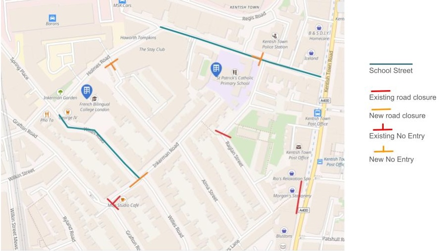
Westbound motor vehicles (except bin lorries and emergency services) are now prohibited from continuing on Holmes west of Raglan Street


The footway outside St Patrick’s School has been widened: this section is one-way eastbound except for cycles. West of here Holmes Road is two-way. The closure of Raglan Street has been much enhanced by the addition of a rain garden.


The Collège Français Bilingue de Londres (CFBL school) is on Holmes Road between Cathcart Street and Willes Road but the entrances are in Cathcart Street and Willes Road. Cathcart Street is now No Entry to motor vehicles at Holmes Road and Willes Road is now No Entry at Inkerman Road.


The new planters at the restrictions on Cathcart Street and Inkerman Road are attractive. We hope that they can eventually be replaced by rain gardens when this part of the scheme is made permanent.

This scheme has prevented westbound rat-running along Holmes Road between Kentish Town Road and Grafton Road. But has it created an new mini-LTN and has it extended the Queen’s Crescent LTN?
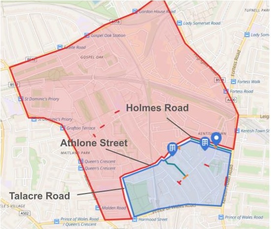
The new restrictions make the blue area a mini-LTN. But there is still an eastbound rat-run along Talacre Road, Athlone Street and Holmes Road separating it from the pink area.
Bonny Street – Camden Gardens
The motivation for this scheme is to provide two-way cycling between Bonny Street and Camden Gardens: the main feature is a contraflow cycle lane on the west side of Camden Street.
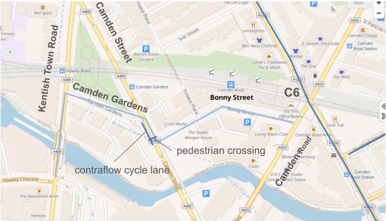


Southbound cyclists on Camden Street may enter Camden Gardens over the new continuous footway (Fig B4) while those in the contraflow enter from behind an island. (Fig B3)
Cyclists in Bonny Street wait at the Give Way (Fig B1) for a gap in the traffic that will allow them to cross over into the contraflow cycle lane. The traffic will be stopped if someone uses the pedestrian crossing and there are gaps every time it is held at the signals at Kentish Town Road.
Cyclists enter the contraflow cycle lane to the south of the pedestrian crossing (Fig B2) and will be held at the signal if someone is crossing.


The light blue line on the map above shows the cycling link between Kentish Town Road and Camden Road; this new scheme allows it to be used in both directions. The scheme could be extended by improvements at the junction of Camden Road – Royal College Street to enable the link to continue in both directions between Bonny Street and the C6 on Royal College Street (south).
Just a road closure of Gordon Square north?
Usually when we talk about a ‘road closure’ we just mean that you can’t drive right through the road from one end to the other. We have a few examples in our discussion of Holmes Road above. All road closures result in fewer car journeys and offer opportunities to make different use of the road space, for example for greening.
Gordon Square north has the Institute of Archaeology on one side and Gordon Square garden on the other. It is now closed to motor vehicles at both ends with a wide cycle track running along the side by the gardens. The remainder of the space has been taken up with furniture so that people can sit out as well as plenty of planting.


