
We have made a spreadsheet listing the bus stops on protected cycle tracks in Camden, classifying each one as Bypass, InLine, SUBB (shared use bus boarder) or RCS. RCS refers to the original Royal College Street bus stops from which SUBBS were derived. We note the width of each which should be at least 2.5m for Bus Stop Bypass islands and 2m for SUBBs and RCSs. We sometimes use the category “Bypass under construction” from when the work starts on site until the zebras and other markings are complete (but we don’t wait for the shelter to be moved).
Larger Map. The details (e.g. substandard widths are shown in red) in the Google Sheet which is here.
The sheet and the map include the bus stops on the Islington side of York Way (which are included in the above counts as they are part of a Camden scheme) and two on Farringdon Road just south of the Camden border which are not included in the above counts.
Clicking on a pin will produce a popup with more information about the bus stop. We note whether it conforms to the standards (see below) e.g. at a bus stop bypass, is a zebra painted on the cycle track and is the shelter on the island. A few of these bus stops are narrower than the standard (see below) but there is insufficient road width to increase them and they seem useful so we have not “failed” them.
The four bus stops classified as ‘too narrow’ are:
- Royal College Street, South of Ivor Street: (RCS). Width 1.7m A little narrow but the road has very little extra space
- Camden Park Road, Opposite Cliff Villas: (Bypass) Island width 1.7m, Track 1.5m. Shelter on footway. The island is much too narrow. Could a few more centimetres be found from the road?
- Chalk Farm Road NB, Outside Stables Market: (Bypass) Island width 2.0m, Track 1.5m.
- Pancras Road, Opposite Chenies Place: Island width 2.0m, Track 1.5m. Also the layout is odd.
InLine bus stops
See Inclusive Design at Bus Stop Bypasses and Continuous Footways by Living Streets (final report expected May 2023).
Having considered options in depth, we have concluded that the biggest problem created by returning cyclists to the carriageway at bus stops is not actually, as is commonly stated, related to their interaction with buses. Instead this problem is the lack of protection for those cyclists, for a substantial distance, from all the ordinary (non-bus) traffic.
We are very concerned about the 6 such bus stops on the downhill side of Haverstock Hill.
Warnings to passengers when alighting at BSBs and SUBBs
We are very pleased to note that TfL buses on most of the routes in Camden with BSBs and SUBBs now warn alighting passengers with audio and textual announcements to cross the cycle path with care “for their own safety”. This is a very welcome effort by TfL. We trust that it will become a default for bus routes with BSBs and SUBBs throughout London.
We have referred to the following standards:
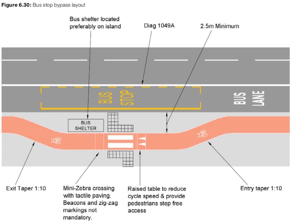 DfT Cycle Infrastructure Design (LTN-1/20 July 2020) section 6.6.8 and Figure 6.30 (p.70).
- “The island should be a minimum of 2.5m wide, which will accommodate parents and buggies, visually impaired people with a guide dog or a person using a wheelchair to allow a bus wheelchair ramp to be deployed”.
- Accessible Bus Stop Design Guidance, TfL (2017). This discusses Cycle Facilities in Chapter 10.
- 2 metres clear width of footway should be retained
- crossing point distinguishable (they mention zebras and we take this as a standard)
- sinusoidal ramp up and down
- shelter and flag near the front of the bus stop cage
-
-
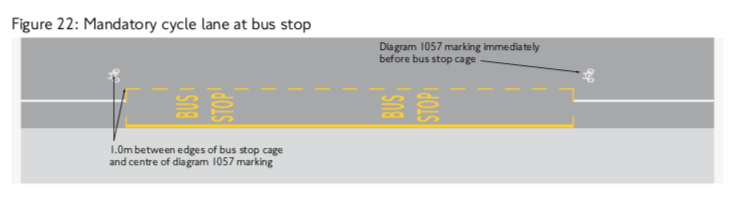
Mandatory cycle lane at bus stop Figure 22. We call these “InLine” Just specifies logos at each end of the bus stop cage.
-
- Shared use Bus Boarders Design Guidance written by Camden following discussion with TfL. We refer to these as SUBBs. This document gives template designs for both Bus Stop Bypasses and SUBBs.
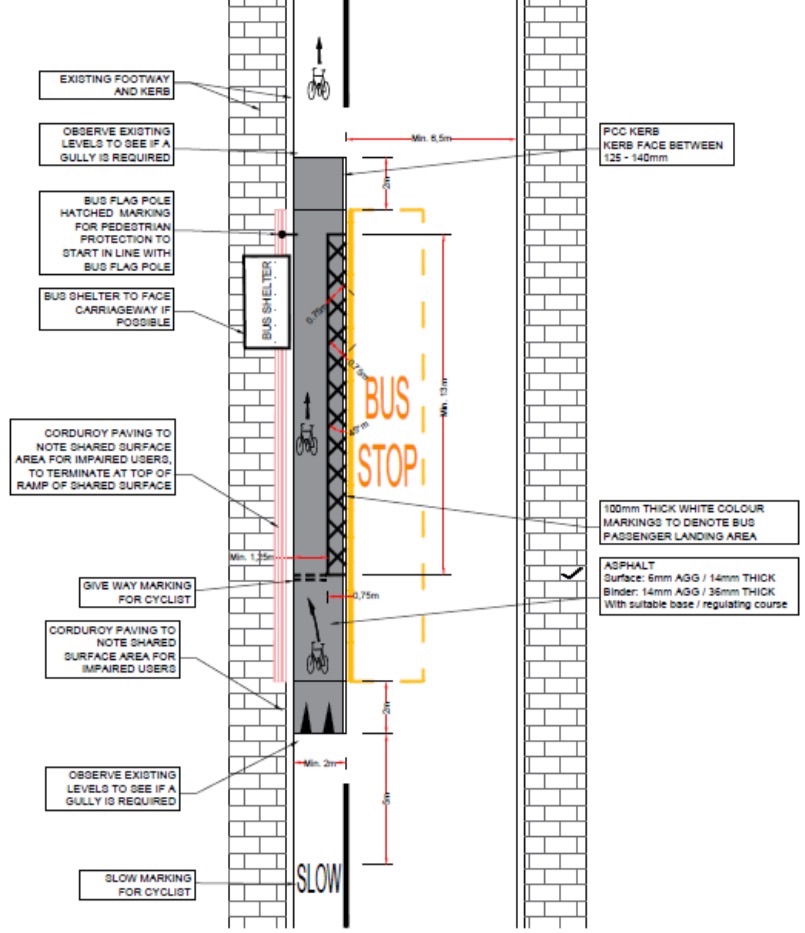 SUBBs:
- Raised paving area constructed in asphalt, at a minimum width of 2m
- White paint markings on raised paving area include ‘Give Way’ markings for cyclists and a hatched area to highlight general pedestrian landing area and to visually narrow cycling area to encourage slower speeds when a bus not present;
- ‘Slow’ markings added to cycle lane on approach to SUBB to advise cyclists to take greater care at all times.
- Flag and pole (including bus time table information) to be kept on the footway to negate need for bus passengers to use shared space prior to bus arriving.
- RCS bus stops. These are named after the prototypes in Royal College Street. SUBBS were a formalisation of the RCS stops for use in the new COVID-19 cycle lanes where the road width was insufficient for bus stop bypasses.
Talk
George Coulouris’ gave this short talk to the ‘Ideas with Beers’ Zoom meeting on 27 July 2021:
Bus stops on cycle tracks:
How can we make them comfortable for all?
In Camden there are already 36 bus stops adjacent to protected cycle tracks, with more to come. Their design presents a few problems. Further ideas may be needed to make them comfortable for everyone.
Further reading
Robert Weetman’s 2017 Blog showing the wide range of Island Bus Stops and SUBBs in Copenhagen