This map shows progress in carrying out the proposals in Camden Council’s Cycling Action Plan (updated in 2022 See Appendix A Figures 4.3 and 4.4). The total segregated cycle network by 2025 under these plans would be around 40km.
Our map records:
- all of the protected links (segregated) as they are built (shown in purple).
- the secondary links (shown in ‘orangered‘); these are signed and mostly have low traffic counts (i.e. less than 2000 pcus per day)
- the remaining proposed secondary routes not yet implemented (orange lines).
We have put pins on all of the routes in the first two groups and on some of those not yet implemented – for study as to how they can become part of the network.
Click any one of the pins to get information about the length of that section and
- For the protected links whether there are tracks in both directions and the type of infrastructure (e.g. stepped tracks, kerbs or flexible bollards).
- For the secondary links, information as to whether they can be considered to have low traffic and whether they are signed
- For the proposed secondary links, notes on what’s needed for them to be included in the network.
Larger Map. The Google Sheet on which it is based is here. And for people who can’t access Google Docs, a PDF is here.
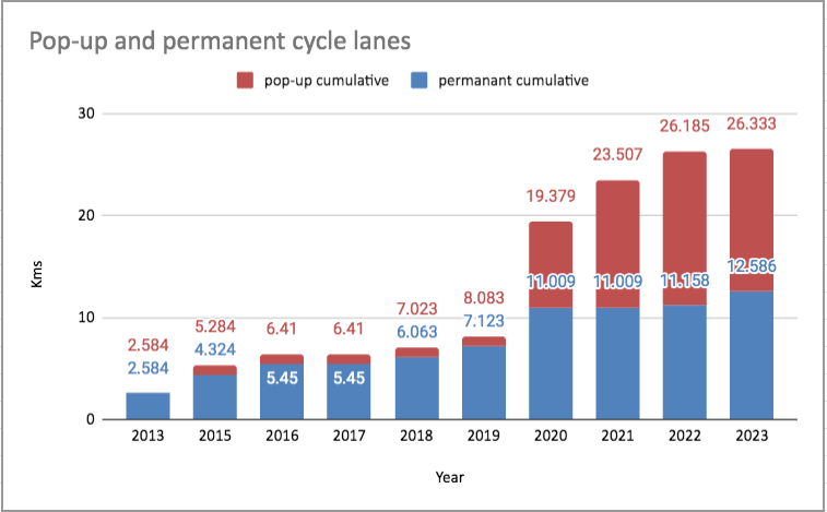
The new interactive chart (Pop-up and permanent cycle lanes) shows Camden’s progress in replacing flexible bollards (or Orcas) with stepped tracks (or kerbs). We refer to the former as pop-up and the latter as permanent. Roll your cursor over the stacked columns to see more detail (e.g. the pop-up counts).
Camden’s first example of pop-up cycle lanes was in Tavistock Place westbound in 2015 with Orcas. Since 2020, starting with TfL’s Streetspace Programme during the pandemic, cycle lanes including Prince of Wales Road eastbound, York Way and Haverstock Hill have been installed with flexible bollards.
During 2023, the flexible bollards on Prince of Wales Road eastbound were replaced with stepped tracks. Work has also started in York Way (stepped tracks) and on Tavistock Place westbound (kerbs); this is expected to be completed during 2024.
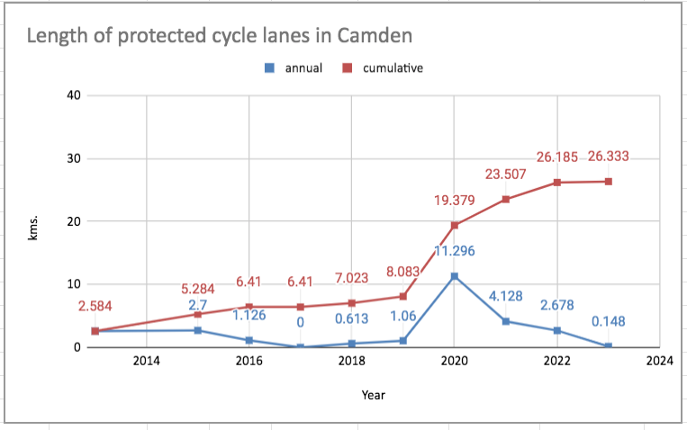
The interactive chart below shows the total lengths of segregated lanes built each year. Roll the cursor over the data points to see the distances in kms.
In case anyone is working in an environment where Google Sheets cannot be accessed, we provide images of the two charts above

Image of the first chart for people who can’t access Google Docs.

Image of the second chart for people who can’t access Google Docs.
Proposed secondary links
Some criteria to be considered for acceptance in the network:
Low traffic (well below 2000 pcus per day), signed, safe junctions, connection to accepted links.
Some examples we hope Camden will consider (click on the pins in the above map for more information).
- Linking between Chalk Farm Road, PoW and C6 up Grafton Road:
- Queen’s Crescent. In LTN, needs crossing over Malden Road
- Malden Road – Ferdinand Road,
- Marsden Street – Wilkin Street. In LTN, needs crossing over Malden Road
- Savernake Road – Nassington Road.
- Linking Hampstead Road with Chalk Farm Road and with C6 via Castlehaven Road:
- Arlington Road and Jamestown Road (in LTN) together with the section of Camden High Street north of Jamestown Road would form a very useful northbound link to the new Chalk Farm Road route and to Castlehaven Road
- The southbound link via Kentish Town Road and Hawley Crescent would need work to make it safe.
- Linking C6 to the Camden Square Route (C50) involving crossings over Camden Road:
- A link from Hawley Road via Jeffreys Street, Wilkin Street (LTN) across Camden Road to Rochester Square
- Anglers Lane – Gaisford Street – Cantelowes Park across Camden Road
- In the west of the borough after the establishment of LTN in the Maygrove, Gardens, Fordwych and Kingsgate areas:
- Fairhazel Gardens – Compayne Gardens and the rest of Q3 then link via Loudoun Road to Elsworthy Road
- Fordwych Road
- Westbere to Lyncroft
- Goldhurst Terrace – Acol Road–Messina Avenue
- Priory Road – Greville Road
Note people will be able to cycle in both directions in all of the above routes so the gain will be double the figures given above


