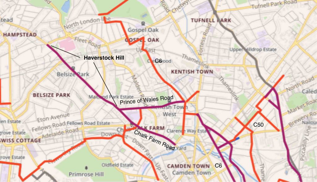
Map showing how the Haverstock Hill cycle route links to the rest of the Camden Cycling Network
On our map, the cycle routes with protected cycle lanes are shown in purple while the routes on quiet roads are shown in orange.
The newly completed extension of the Chalk Farm Road cycle route up Haverstock Hill runs between Prince of Wales Road and Pond Street, providing an additional one km of protected cycle lanes on each side of the road. The entire route on Chalk Farm Road and Haverstock Hill is about 1.8km long.
Haverstock Hill links directly to the route on Prince of Wales Road which can be used to reach the C6 route which runs from south of the Thames via Blackfriars, Kings Cross and Kentish Town to Hampstead Heath. The new northern section of C6 runs through the quiet roads in the West Kentish Town and Savernake LTNs, crossing Mansfield Road on a Tiger Crossing.
The scheme includes four new zebra crossings and one new signalised crossing, bringing the total number of pedestrian crossings to eight.
The junction at England’s Lane has had a minor upgrade with low-level signals and early release for cycles.
This stretch of road includes three bus stops on each side. Unfortunately, the road isn’t wide enough to accommodate bus stop bypasses (e.g. like this one on Chalk Farm Road) . Instead, three new shared-use bus stops (SUBBs) have been constructed on the uphill side. We will discuss the downhill bus-stops later in the article.
The route is starting to be well-used, with mid-week (Tue-Thur) counts of around 1000 a day from mid-September 2022 at a count point just south of England’s Lane; and 600-700 a day at a point close to Belsize Park station.
1. Lanes, wands and logos
Click on any photo to see an enlargement.
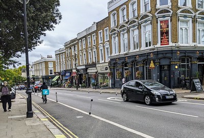
The cycle lanes are 2m wide wherever possible but a little less wide where space is short even after gaining all available space in the road. We start our review from the southern end at the junction of Prince of Wales Road where the downhill cycle lane is 2m wide and the uphill lane 1.8m wide. Photo 1 shows the downhill cycle lane just opposite the junction with Steele’s Road. At this point the cycle lanes are 1.9m wide, leaving 6.1m for the two motor traffic lanes.
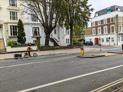
Continuing north, Photo 2 shows a view across the downhill cycle lane viewed from the junction with Parkhill Road. At this point the cycle lanes are 2m wide, leaving 6.4m for the two motor traffic lanes.
The cycle lanes are marked as mandatory (with continuous white lines), protected by flexible wands and have logos painted at intervals. The double yellow lines and double ‘blips’* indicate that parking and loading are forbidden.
*blips: the yellow bands marked across the kerb stones visible in Photos 1 and 2.
There are some breaks in the protection, for example, in Photo 6 at the end of the zig-zags for the pedestrian crossing and in Photo 2 on the exit from the junction with Parkhill Road.
Photo 3 is just south of Antrim Road, looking uphill. Right through this section from the England’s Lane junction, the cycle lanes are 2m wide leaving 6.4 m for the two motor traffic lanes. The gap in the cycle lane on the other side of the road accommodates an ‘in line’ bus stop (described later).
In the next section from Upper Park Road to Belsize Grove, the cycle lanes are 2m wide leaving 6.4 m for the two motor traffic lanes with one exception shown in Photo 4 which is taken from opposite Upper Park Road. At this point, the cycle lanes are narrowed to 1.6m and the motor lanes to 3m each so as to accommodate the refuge island which also protects right turns into Upper Park Road.
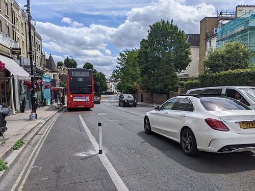
In the section from Downside Crescent to Howitt Road, the cycle lanes narrow from 2m down to 1.7 m; Photo 5 looks across at the shops south of Howitt Road (the logo by the red car is associated with an in-line bus stop – see Section 3 ).
Photo 6 is a view across Haverstock Hill from close to the signalised pedestrian crossing south of Glenloch Road (you can see the ‘zebra tails’ – zig-zag lines leading to the crossing – where no wands have been placed although they probably could be. The road is wider here and the cycle lanes from Glenloch Road northbound are 2.2m wide.
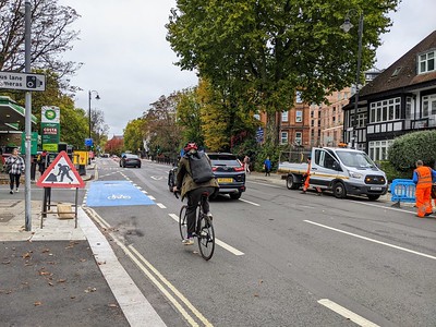
Photo 7: Looking uphill across the junction with Belsize Avenue after which the only provision is a Bus Lane
The 2m uphill cycle lanes continue as far as Belsize Avenue (Photo 7 in which the dashed lines are a mystery). But for the remainder of the route up to Pond Street cyclists are expected to share the full-time bus lane as far as Belsize lane.
On the downhill side, a narrow mandatory cycle lane (1.9m down to 1.2 m) is provided from Rowland Hill Street down the hill as far as Ornan Road where a 2m wide southbound wand-protected cycle lane starts. †
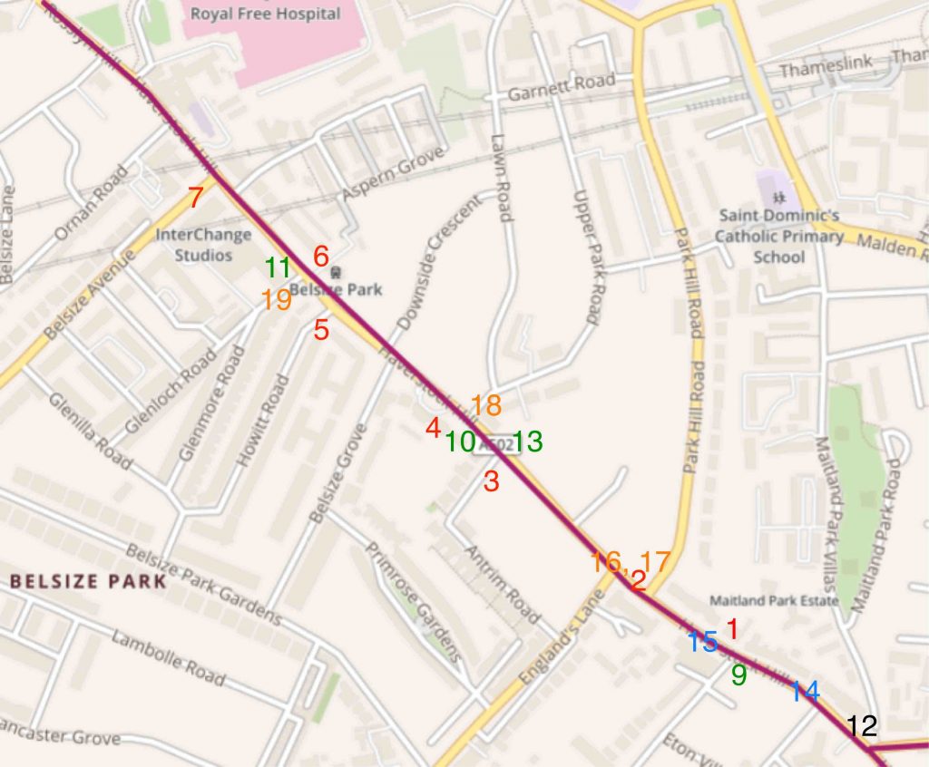
Map of Haverstock Hill showing the locations of the photos
2. Shared-use bus boarders (SUBBs)
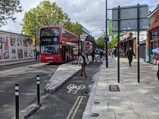
All of our protected cycle routes are on main roads and almost all of these roads are bus routes (Tavistock Place, St Pancras Way and Gower Street are exceptions). The southern end of this route on Chalk Farm Road is a little wider and there is room to build bus stop bypasses – an arrangement where bus passengers are provided with an island for waiting and for getting on and off the bus while the cycle lane passes behind the island, as shown in Photo 8. The island is supposed to be at least 2.5m wide and must be taken from space in the road (not from the footway). It should be clear from the above discussion that the new section of Haverstock Hill is only just wide enough to accommodate cycle lanes.
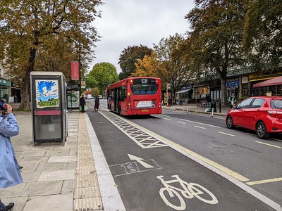
One alternative (called a SUBB or shared use bus boarder) is to allocate a narrow strip of the cycle lane for bus passengers to stand on when getting on and off the bus as shown in Photo 9. The narrow strip has criss-cross markings. If you enlarge the photo you will be able to see a passenger waiting to board the bus. Camden prototyped two SUBBs on the Prince of Wales Road eastbound cycle track (built in 2020), developing a standard that included a slope up to slow down cyclists. They also used them on the northbound uphill York Way cycle track. The safety of the bus passengers depends entirely on the cyclists stopping whenever a bus is at the stop.
All of the bus stops on the uphill side of Haverstock Hill (north of Prince of Wales Road) are implemented as SUBBs. Photos 10 and 11 show the two other SUBBs, one just north of Upper Park Road and the other just north of Glenloch Road.
People report that they find it hard to stop because they don’t like to lose momentum when going uphill but the five SUBBs have been in place on the uphill side of York Way since 2020 and we are not aware of any serious issues.
3. The ‘In-line’ bus stops on the downhill side of Haverstock Hill
Camden Council decided not to use SUBBs on the downhill side because the slope is quite steep, particularly in the section between Eton Road and Steele’s Road. In this case, there is a risk that some cyclists might fail to stop when a bus is at the stop and passengers are getting on and off. The alternative is to allow the bus stop rectangle to interrupt the cycle lane – and when a bus is at the stop, cyclists either can wait or ride round the bus. We refer to this arrangement as an In-Line bus stop.
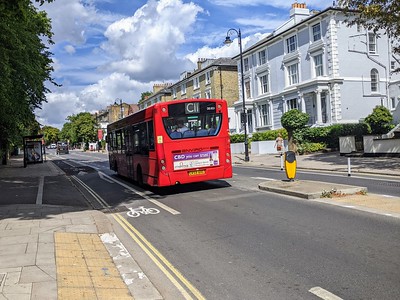
Photo 12 shows the In-line bus stop just north of Prince of Wales Road (the cycle logo is telling people that if they can’t wait they should go round the bus rather than between the bus and the kerb) and Photo 13 shows the one opposite Antrim Grove.
There are two more in-line bus stops, further up the hill, near to Downshire Crescent and Aspern Grove.
This style of bus stop leaves a substantial unprotected length of road through the bus stop. We would prefer to see SUBBs at these bus stops at least where the gradient isn’t so steep (it is steep in Photo 12).
4. Pedestrian crossings
Before this scheme was implemented there were several informal crossing places with islands in the middle of the road. The islands needed to be removed to make room for the cycle lanes and the crossings were made into zebras for the convenience of pedestrians (see Photo 14).
Any pedestrian crossing (zebra or with a signal) has ‘zebra tails’ before and after on both sides of the road, which causes a gap in the protective wands. For this reason, the zebra tails need to be kept to a minimum length.
But we are aware of at least one location in Camden where wands have been planted on zebra tails. See StreetView dated August 2022. We would like to see this practice on all trial routes.
There are now eight pedestrian crossings in this 1 km of road (two have signals and the other six are zebras)
5. The junctions with signals
Prince of Wales Road / Haverstock Hill
The junction with Prince of Wales Road was upgraded in 2020 as part of the scheme for the westbound lanes on Prince of Wales Road. The central island on Haverstock Hill was moved a little eastwards to allow space for a future northbound cycle lane (which has proved to be a very useful foresight). The signals were upgraded to provide low-level signals and early release for cyclists on all three arms and pedestrians have an all-green stage. Camden consulted on a proposal to allow southbound cyclists on Haverstock Hill to bypass the signal when turning left but they had to abandon the scheme as it involved sharing limited space with pedestrians – it would have been good to have a bypass but it seemed to be unfeasible here.
England’s Lane / Haverstock Hill
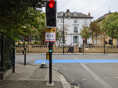
This junction has been upgraded as part of the new scheme. All arms have low-level signals and early release for cycles. Pedestrians have an all-green stage and cross in a single stage without any intervening islands.
This is a good start but it would have been preferable to have a dedicated signal stage for cycles on Haverstock Hill so as to improve safety by removing potential left hook conflicts for northbound cycles and to make it safe for southbound cycles to turn right into England’s Lane.
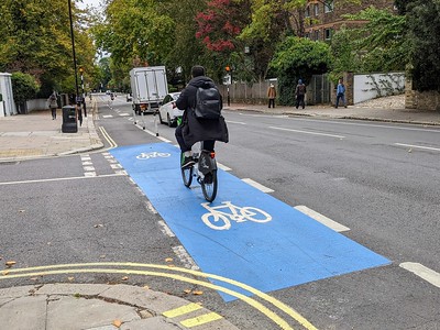
As with all of the junctions, the blue paint emphasises the fact that the cycle lane goes through the junction. The cycle logos will probably appear soon on the uphill side of the road.
Pond Street / Haverstock Hill junction
When we visited on 14th October this junction was ‘under construction’: that is, the old signals had been removed and replaced by temporary signals.
6. The side road junctions without signals
At all of these junctions, the traffic on Haverstock Hill has priority, while the traffic on the side roads must give way.
The main issue for cyclists on Haverstock Hill is that they should be able to pass the side road safely: that is, without being cut off by a motor vehicle turning left or right into the side road and without being hit by a motor vehicle emerging from the side road.
In this scheme, the cycle lane is marked across each of the side roads with bright blue paint and with cycle logos over the paint.
7. The future permanent scheme
The current scheme is implemented under an 18-month ETO (experimental traffic order) and will be followed up with a consultation on making it permanent towards the end of that period. The flexible wands are a very good approach to getting new schemes on the ground rapidly but there are better solutions for permanent schemes.
Camden chose stepped tracks for their permanent schemes, trying them out on Pancras Road in 2016 (Photo 20) and following up with Midland Road and Gower Street. Stepped tracks have the advantage of using all of the available width (because they need no kerb or wand protection) and they wear very well. But they do require the re-siting of the kerbside drains so are not simple yto build.
In other schemes which have been agreed to make permanent (e.g. Prince of Wales Road eastbound, York Way and Chalk Farm Road), the flexible wands are to be replaced by stepped tracks. Work has already started on the stepped tracks on Prince of Wales Road.
Other upgrades for permanent schemes include the use of blended junctions at side roads (that is, junctions with continuous footway).
8. Conclusions
We congratulate Camden Council for having pushed through this scheme in face of all the opposition by people who can’t see the benefits. No doubt the shopkeepers, cafes and restaurants will find their trade increases as it always does when people travel by bicycle rather than in motor cars. Unfortunately, there is one thing that we really don’t like and that is the three loading bays that interrupt the cycle lanes – they should be in the side streets or inset like the ones outside the Old Town Hall; if we must have them, they should be enforced so that they are used as specified on the signs, for loading only and between the hours of 10 am and noon, Monday to Saturday.
This write-up is intended to give the flavour of the scheme and to encourage people to try out this new route and perhaps stop for a coffee! Our audit will follow.

