| 2024 |
2025 |
CCC Comments/Asks |
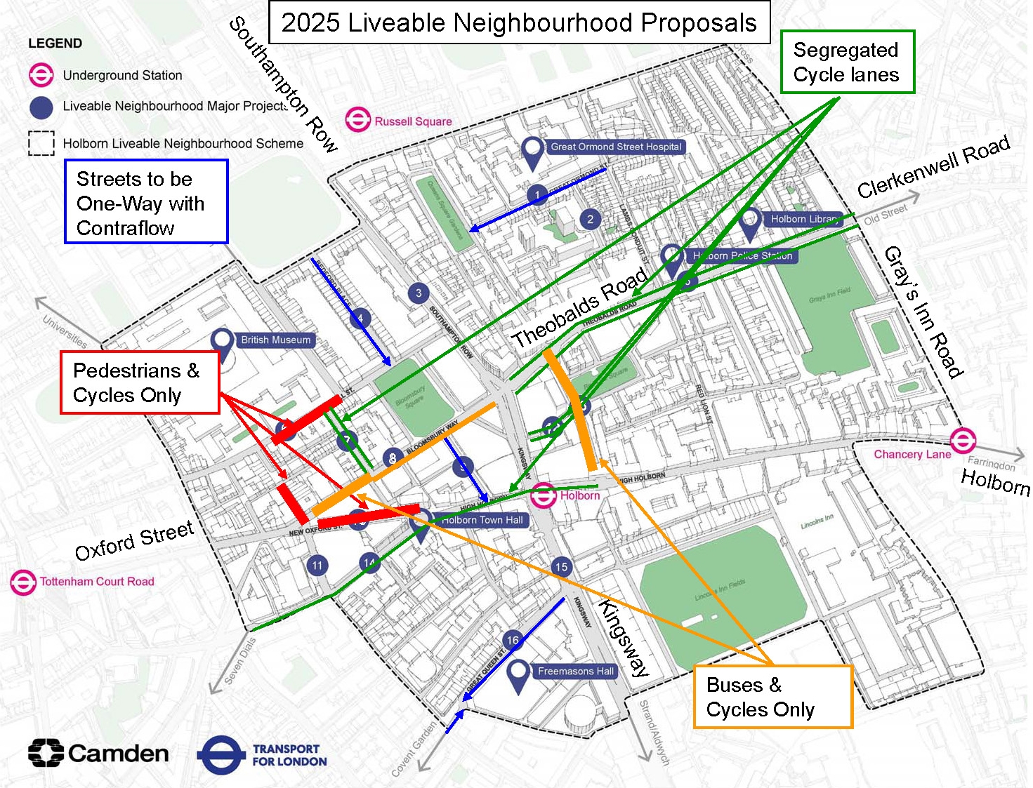
| Bedford Place (4)
Exploring improvements to the look and feel of the area, upgrading the materials on the road and pavement, adding plants and seating, and making it easier to cross the road which could be changed to one way |
- Making the road one-way southbound with cycling allowed in both directions
- Creating new areas for planting, seating, cycle parking, bin storage and drop off and loading zones for the hotels by removing pay by phone parking spaces
- Spaces for children to play integrated into the seating and pavement
- New crossing points for pedestrians without signals
- Adding historic information about the street included in the design materials
- Adding a rain garden (areas of planting that soak up rainwater and help prevent local flooding)
- Using a coloured road surface at the junctions to make the street more pedestrian friendly
|
Positive – Avoids left-hooks on Bedford Place at Russell Square and on Great Russell Street. |
| Bloomsbury Way (8)
Exploring changing the road to a bus and cycle only route |
- Making the road open only to buses and bicycles between Bury Place and New Oxford Street to improve air quality and road safety
- Planting new trees where possible to create more shade
- Creating a new pocket park with seating, plants and trees on the corner with Bloomsbury Square
- Widening the pavement outside St George’s Church
- Using a coloured road surface at junctions to make the street more pedestrian friendly
|
Negative – Was to be from Southampton Row to New Oxford Street.
Essential to have segregated lanes for cycles in both directions, together with safe junctions allowing all movements. One approach might be a central two-way cycle lane, as we suggested to Camden in 2018 – also see Nantes example.
The “Clerkenwell Blvd” can’t stop at Southampton Row; it needs to continue down Bloomsbury Way
Redesign junction at New Oxford Street-Museum Street to make it safe for cycles to make all turns |
| Bury Place (7)
Exploring restricting traffic to loading, access and cycling only |
- Adding new paving and materials similar to those used around the British Museum
- Adding a segregated two-way cycle lane
- Adding new trees to the northern section, planted in locations that don’t block the view to the museum
- Creating more space outside Pied Bull Yard for businesses to use
|
Better than nothing but not as good as originally planned. Note that this forms part of C52 |
| Fisher Street/Catton Street (12)
Exploring restricting traffic to loading, access and cycling only |
- Adding new cycle lanes on both streets
- Planting new trees where possible to create shade and adding new areas of planting
- Improving road safety by continuing the paving material across the road at junctions
- Public artwork and new lighting
|
Better than nothing but not as good as originally planned |
| Great Ormond Street (1)
Exploring a ‘Healthy Hospital Street’, including changing the traffic to one-way westbound, with plants and seating, widened pavements and parking changes |
- Changing the street to one way westbound except for ambulances which could travel in both directions to enter the hospital
- Creating a new green space for play and socialising with new trees, planting and seating
- Adding new rain gardens (areas of planting that soak up rainwater and help prevent local flooding)
- Relaying the pavement to get rid of trip hazards and make the surface easier to use
- Building two new zebra crossings – one in front of the entrance to the hospital and one at the junction with Lamb’s Conduit Street
- New feature lighting and the potential for a decorative water feature
|
Should allow two-way cycling, clearly delineated |
| Great Queen Street (16)
Exploring a new public space opposite Freemasons Hall created by pedestrianizing Great Queen Street between Drury Lane and Wild Street alongside improvements to the look and feel of the area, new pedestrian crossings, widened pavements, plants and seats and making it easier to cross the road which could be changed to one way |
- Making the street one way westbound for traffic between Kingsway to Wild Street with two way cycling allowed
- Making the street one way eastbound for traffic between Drury Lane and Wild Street with two way cycling allowed
- Open up space for people by relocating paid for, motorbike plus dockless cycle parking to nearby streets including Drury Lane and Wild Street
- Changing the colour of the road surface to match the pavement to slow traffic and make the street more pedestrian friendly
- Repaving the parking spaces and pedestrian crossings in higher quality materials
- Widening the pedestrian crossings and bringing them up to road level to make it easier to cross
- Creating space for outdoor dining against the edges of buildings with moveable planters
- Adding new areas of planting and trees wherever possible for extra shade
|
Was to be fully pedestrianised
Design of street will be key. Should treat motors as guests but also have a clear cycle path, shared with motors only if predicted traffic counts are below 2000 pcu/day. This is part of the C52 cycleway. It should be signed properly. Cycle safety when crossing between the westbound and eastbound sections (at Wild Street) must be considered. |
| Great Russell Street (6)
Exploring restricting traffic in the section outside the British Museum to create a new public space with trees and planting open only to pedestrians and cycling (with access to side roads allowed for local traffic) |
- Pedestrianizing the street between Museum Street and Montague Street with emergency service and waste collection access
- Adding new trees and low level planting to provide shelter plus integrated seating designed to take advantage of different views
- Creating space for businesses to have outdoor seating
- Opportunities for children to have space to play
- A taxi pick up and drop off point before the pedestrian area
|
GRS needs to be usable for cycling. It will be a link from Coptic Street to Montague Street and should be shown as a link on the map.
Removal of motor traffic is long overdue and should be implemented in the short term as a ‘quick win’.
Taxis should be sent to Montague Place entrance |
| High Holborn (14)
Exploring changing the stretch of road between Proctor Street and Shaftesbury Avenue to two-way traffic, improving the look and feel of the area and making improvements for pedestrians at the junctions |
- Making the street two way for traffic between Shaftesbury Avenue and Procter Street
- A new segregated cycle lane to support safer cycling
- Adding new areas of planting and trees along the road for more shade, plus a small pocket park in front of the Holborn Tower
- New rain gardens (areas of planting that soak up rain water and help prevent local flooding) and seating in front of the Rosewood Hotel
- Decluttering the area by moving the dockless cycle hire bay outside Waitrose to create more space for people and planting
- Creating coloured bus lanes plus raised areas of road to make crossing the road easier
- Areas of new paving to make the pavement surface easier to use
- Plenty of new seating for people to stop and rest
- Installing direction signs to help people find their way, especially around alleyways and side streets
|
Good to see if it results in safer routes for cycles along Bloomsbury Way
There should be segregated lanes in both directions, not one segregated and one advisory lane as shown in the visualisation. Note that the original announcement of the Holborn LN showed segregated lanes, https://camdencyclists.org.uk/2019/03/great-news-holborn-liveable-neighbourhood/
We expect a protected cycle route in both directions between Red Lion Street and the junction with New Oxford Street |
| Kingsway (15)
Exploring improvements to bus journeys, cycling, pedestrian crossings and the look and feel of the area |
- Adding simple, repeated, and formal plants underneath the existing London Plane trees to celebrate the current feeling of a wide Parisian style boulevard
- Adding new low-level planting to the centre of the road
- Improving the entrance to Holborn Station
- Adding some seating along the edge of the planting areas
- Improving the passageways with changes like new artwork, information, lighting, direct signs and paving
- Providing better and more accessible locations for cycle parking
- Making it easier for people to find their way to Lincoln’s Inn Fields by adding signage
- Adding interpretation or artwork to share the history of the Kingsway tram tunnel
- Exploring the option for feature lighting in the trees
- Supporting the existing kiosks
- Improving road safety with coloured junctions and crossings
- Adding raised crossing points on the side roads to make the area more pedestrian friendly
- Decluttering the area to help support businesses use the space, like at Sicilian Avenue
|
Disappointing to see nothing specific for cycling. None of the maps have ever shown any cycle lanes on this alignment but the network density is rather low here (Red Lion Street to Bury Place is about 500m) |
| Museum Street (11)
Exploring changing the road to one-way southbound with cycling in both directions |
- Creating a space which makes it easy for pedestrians to reach the British Museum. This includes pedestrianizing the area between Little Russell Street and Bloomsbury Way
- Adding trees and planting which frame the view towards the British Museum
- Adding seating, new lighting and high quality materials throughout.
- Creating space outside the businesses for outdoor dining and where people can still easily pass by
- Building a new zebra crossing to help people move across Little Russell Street
|
Good to see the existing pedestrianisation extended south to Bloomsbury Way
Ensure that there is a clear way through for cycles. More seating might be too much. |
| New Oxford Street (10)
Exploring restricting traffic to create a new public space with trees and planting open only to pedestrians and cycling |
- Creating a brand new space for people and nature in the heart of central London
- Adding new trees, plants, and space for people to stop and enjoy with seating throughout
- Two different paths for people to take – a direct route through the space and a second winding path to enjoy the planting
- Space for businesses to have outdoor dining while still leaving space for people to pass by
- Possible space for a kiosk serving food and drinks
- New high quality materials, lighting and a coloured surface material at the junction to improve road safety and make the space more pedestrian friendly
- Creating opportunities for children to play in the space
|
Does not specifically refer to pedestrianisation
Design of street will be key. Should have a clear cycle path to indicate to pedestrians that cycles should be expected.
This is part of C52 (between Bury Place and Newton Street) as well as a useful continuation of a route from Red Lion Street along High Holborn. |
| Orde Hall Street (2)
Exploring improvements for pedestrians plus two way cycling and restricting the right turn into Great Ormond Street |
- Creating a street for the community with new plants and trees where possible
- Working with the community to shape the space with the option to help to look after it
- Growing berries and edible plants for the benefit of people and nature
- Creating space for children to play and adding rain gardens (areas of planting that soak up rainwater and help prevent local flooding)
- Creating more space for people by removing some resident parking and the park railings
- Upgrading the road material to a buff coloured surface
|
Right turn is already banned |
| Procter Street/Drake Street (13)
Exploring restricting traffic to loading, access, cycling and buses only |
- Making Procter Street buses, bicycles and taxis only (except for local access)
- Planting new trees where possible to create a new avenue of trees the length of the two streets
- New rain gardens (areas of planting that soak up rain water and help prevent local flooding) and seating along the road to rest
- Adding a dockless cycle hire and e-scooter bay which would be relocated from High Holborn onto Red Lion Square.
|
Very positive. Good that cycles are already segregated so conflict with buses will not arise. It would give space for a contraflow cycle lane which would compensate for not being able to cycle safely on Kingsway. And closing it to all motors except buses and taxis should make the junction with High Holborn work better than the current situation where some motors ignore the signals. |
| Southampton Place (9)
Exploring restricting traffic to loading, access and cycling only and improving the look and feel of the area |
- Making the street one-way southbound with cycling allowed in both directions
- Adding seating around the historic statue at Bloomsbury Square Gardens
- Separating the permit holder parking bays and loading bays with areas of planting
- Adding new trees wherever possible
- Raised crossing points at the junction with Bloomsbury Way and High Holborn to make the area more pedestrian friendly
- Planting new rain gardens (areas of planting that soak up rainwater and help prevent local flooding)
- New seating for people to stop and rest
|
Will need segregated cycle lanes |
| Southampton Row (3)
Exploring improvements to bus journeys, pedestrian crossings and the look and feel of the area |
- New paving outside the Bedford Hotel to make the pavement surface easier to use
- Relaying the existing pavement across the area to remove trip hazards
- Decluttering the area by taking away railings that aren’t needed like those outside Cosmo Place
- Improving road safety by using different colour road materials at pedestrian crossings, making the street more pedestrian friendly
|
Disappointing to see nothing specific for cycling |
| Theobalds Road (5)
Exploring changing the stretch between Southampton Row and Proctor Street to two-way traffic, and adding segregated cycle lanes in both directions up to Gray’s Inn Road. Other ideas include adding pedestrian crossings, planting, seating and improving the look and feel of the area |
- Adding segregated cycle lanes for safer cycling between Southampton Row and Gray’s Inn Road in both directions
- Widening the pavements wherever possible to give more space to pedestrians including outside 25-47 which also has space for more plants, trees and seating
- Adding new trees wherever possible for more shade and planting along the road to separate people from traffic
- Improving road safety with coloured junctions and crossings also making the area more pedestrian friendly
- Creating a new pocket park on Harper Street with seating and opportunities for children to have space to play
- Highlighting pedestrian priority with raised crossing points on the side roads
- Spotlighting the library by adding patterned paving outside. We could also add specially designed seating with play opportunities, cycle storage plus trees for shade.
|
Very positive. Need to redesign the junction at Southampton Row- Bloomsbury Way and also the junction at Red Lion Street. |