Full screen map [Use sliders at top right of map to vary transparencies of the layers]
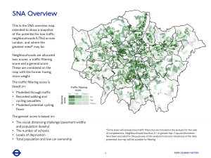
The above map overlays the existing LTNs in all London boroughs (taken from this map as at 18 March 2021) over TFL’s Overview diagram taken from their Streetspace funding and guidance report, Appendix Six (b) Strategic Neighbourhoods Analysis (June 2020).
(Existing LTNs taken from this map processed as follows:
Export the LTNs as a KML file; Convert the KML to a PDF using MyGeodata Converter; Convert the PDF to a PNG file (e.g. with Preview); Make the background of the PNG transparent (e.g. using Online PNG Tools); Use Maptiler to register the resulting PNG file over an OSM background map.)
George Coulouris
21 March 2021


