
- Cycle paths through road closures
- West End Project
- And the rest
- Fleet Road and Cressy Road
- Closing comments
Click on any photo to see an enlargement
Cycle paths through road closures
St Paul’s Crescent at Agar Grove
St Paul’s Crescent was closed at the junction with Agar Grove during the 1970s with a view to reducing rat-running through the Camden Square area. Many years ago, cycle tracks were put through the closures of Stratford Villas and Cantelowes Road at Agar Grove. This new cycle track is welcome as it completes the cycle permeability through the roads that used to connect to Agar Grove.


Linstead Street at Netherwood Street

Linstead Street is a quiet road linking Netherwood Street to Kilburn Grange Park. It was closed to through traffic by a line of cycle stands and a pair of trees.
This new permeability measure provides dropped kerbs on both sides and a clearly marked route through for cycling.
Two-way cycling was introduced in a very useful set of one-way streets in the South Hampstead and Kilburn area in 2012. See our report. But that was a long time ago and to the best of our knowledge, there have been no more west of the Finchley Road since then. This makes the Linstead Street scheme very welcome and we very much hope that it will be followed by others.
Fitzrovia area two-way cycling in one-way streets
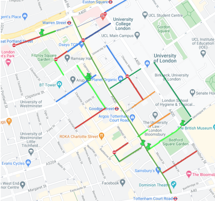
The map above is a coloured extract from our permeability progress map which shows the location of permeability requests in blue and of gains in green. The recent gains are marked in red (Streetspace funded) and orange (West End project).
The recently removed one-way system in Tottenham Court Road (TCR) and Gower Street is accompanied by a web of one-way east-west streets that are still in place. Two-way cycling was introduced in Bedford Square (north), Bayley Street, Percy Street, the western end of Store Street and Endsleigh Gardens in 2010-11 as complementary measures for the cycle hire scheme.
A Fitzrovia improvement scheme in 2012 included two-way cycling in Whitfield Street and Fitzroy Street and Warren Street between Fitzroy Street and Whitfield Street plus the point closure of that section of Warren Street. See our post on Fitzrovia Improvements.
Covid/StreetSpace funding has been used for the following changes
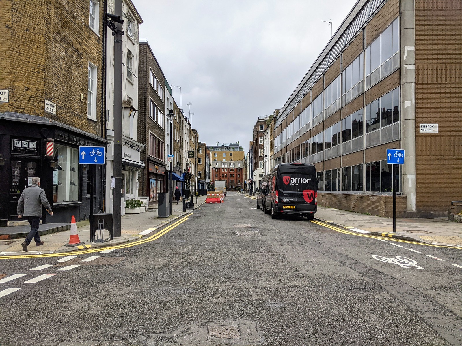
Warren Street west of Fitzroy Street

The 2012 scheme provided two-way cycling on Warren Street between Fitzroy Street and Whitfield Street.
During summer 2020, a second closure was put in to make space for a Streatery – photo on the right.
The new scheme extends westwards to Cleveland Street. But it does not yet deal with the eastern end between Whitfield Street and Tottenham Court Road. We describe the new work on Warren Street in two sections: Fitzroy Street to Conway Street and Conway Street to Cleveland Street.
Fitzroy Street to Conway Street
The section between Fitzroy Street and Conway Street is illustrated in photos 5 and 6.
Photo 5 shows the contraflow cycling signs and one of a pair of logos past the junction (where Warren Street has priority).
Photo 6 shows cycle exceptions to No Entry signs and an entry treatment (a short section of cycle lane with a logo).


Conway Street to Cleveland Street
The section between Conway Street and Cleveland Street has contraflow cycling signs and exit treatment (see photo 7).
This section is two-way for cycling although it isn’t possible to enter Warren Street from Cleveland Street due to the opposing one-ways on the latter.
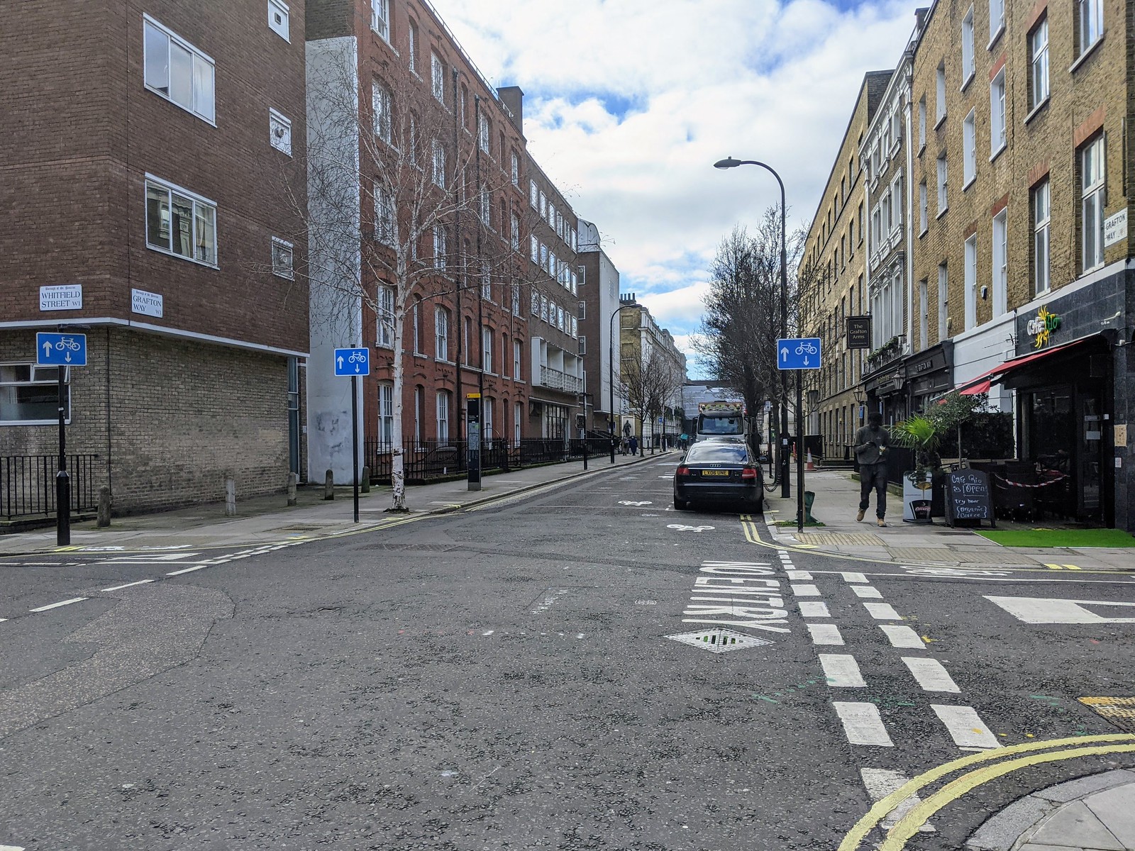
Grafton Way between Fitzroy Street and Whitfield Street
The 2012 scheme ignored Grafton Way. This new scheme makes a two-way connection between Fitzroy Street and Whitfield Street. But it does not deal with the eastern end of Grafton Way between Whitfield Street and Tottenham Court Road.
The new contraflow starts from the south-east corner of Fitzroy Square by extending the contraflow in Fitzroy Street round the corner into Grafton Way – see photo 8.
Photo 9 shows the contraflow cycling signs and a logo at the junction of Whitfield Street where cycles must turn left or right as there is ‘No Entry’ to the eastern end of Grafton Way (behind the photographer)

Tottenham Street between Whitfield Street and Cleveland Street
Tottenham Street is one-way eastbound on one side and one-way westbound on the other side of Charlotte Street. It is a useful east-west connection on which two-way cycling will be a useful gain.
We understand that Camden intends to consider the possibility of two-way cycling in the eastern section that connects to Tottenham Court Road once the Whitfield Gardens scheme is complete. Do we wait in hope.
We describe the sections east and west of Charlotte Street separately.
Between Whitfield Street and Charlotte Street (eastern section)


Photo 10 shows the cycle exception to the No Entry and the entry treatment (a short stretch of cycle lane with a logo) on Tottenham Street at the junction with Whitfield Street.
Photo 1§ shows the contraflow cycling signs and the exit treatment on Tottenham Street at its junction with the eastern side of Charlotte Street.
Charlotte Street to Cleveland Street (western section)


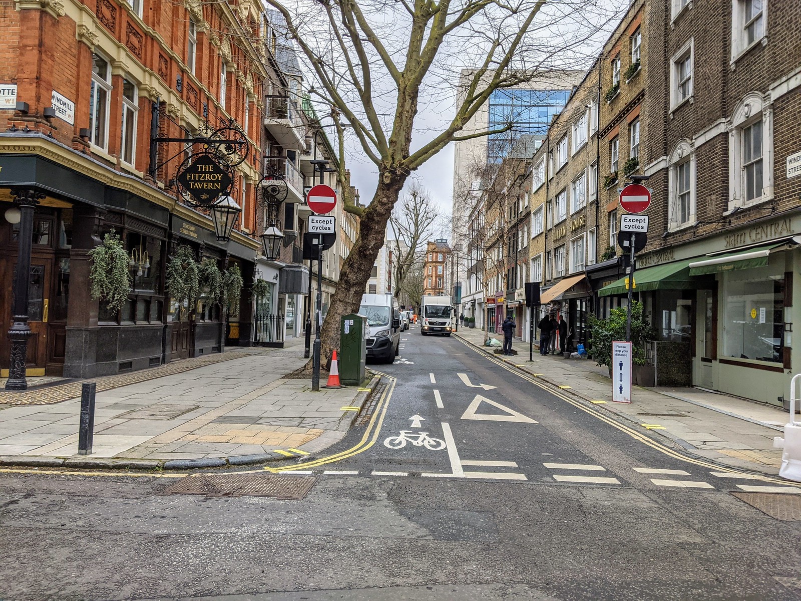
Windmill Street
Windmill Street has for a long time been a useful westbound route from Tottenham Court Road to Charlotte Street with a way for cycles across the diagonal filter at the junction with Whitfield Street. This new measure will provide the corresponding eastbound route and also link with the route up Whitfield Street.

Bedford Avenue

Bedford Avenue is the next road south of Bedford Square and links Bloomsbury Street and Tottenham Court Road. It runs one-way westbound from Bloomsbury Street to Adeline Place and two-way from Adeline Place to Morwell Street. From Morwell Street to Tottenham Court Road, the carriageway has been narrowed and closed with a bollard allowing cyclists in both directions. See photo 16 on the right.
The new scheme makes it possible to cycle both ways through the entire length of Bedford Avenue by providing eastbound contraflow cycling between Adeline Place and Bloomsbury Way.


The West End Project
The biggest permeability gain is of course being able to use both Tottenham Court Road and Gower Street – Bloomsbury Street in both directions. However, it is very sad that Tottenham Court Road north of Grafton Way and the crossing over Euston Road at Euston Circus are useable only by the hardiest cyclists.
These changes also help with east-west permeability, particularly where the side roads are staggered or one-way in the wrong direction.
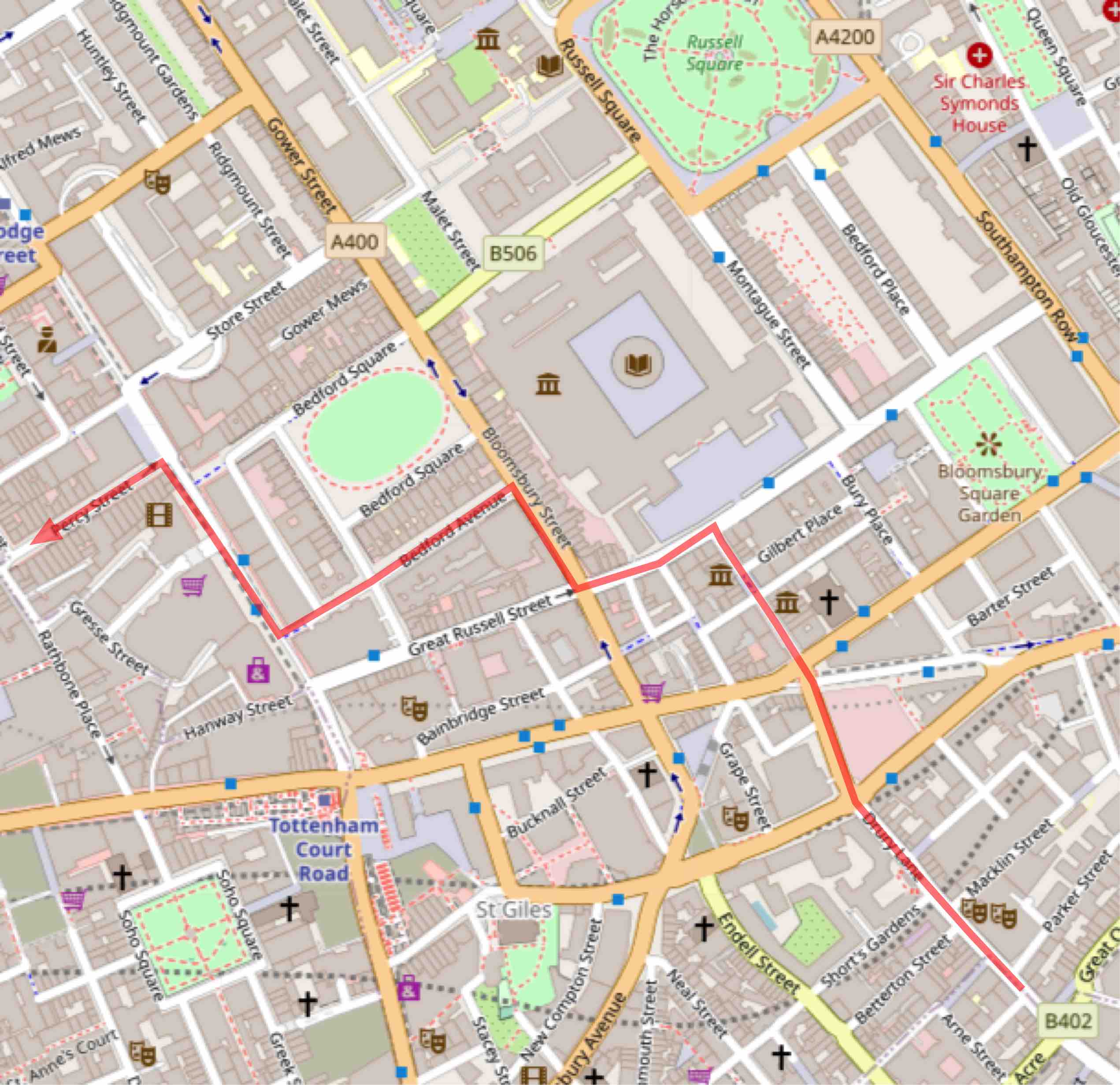
Take, for example, someone coming up Museum Street and hoping to get to Tottenham Court Road: they turn into Great Russell Street and when it meets Bloomsbury Street the continuation is No Entry. Their desire line is illustrated on the map on the right.
In the past, the only choice was to head back down south, whereas now a right turn on Gower Street will soon provide another opportunity to turn west. We will discuss another example in the last section of this post.
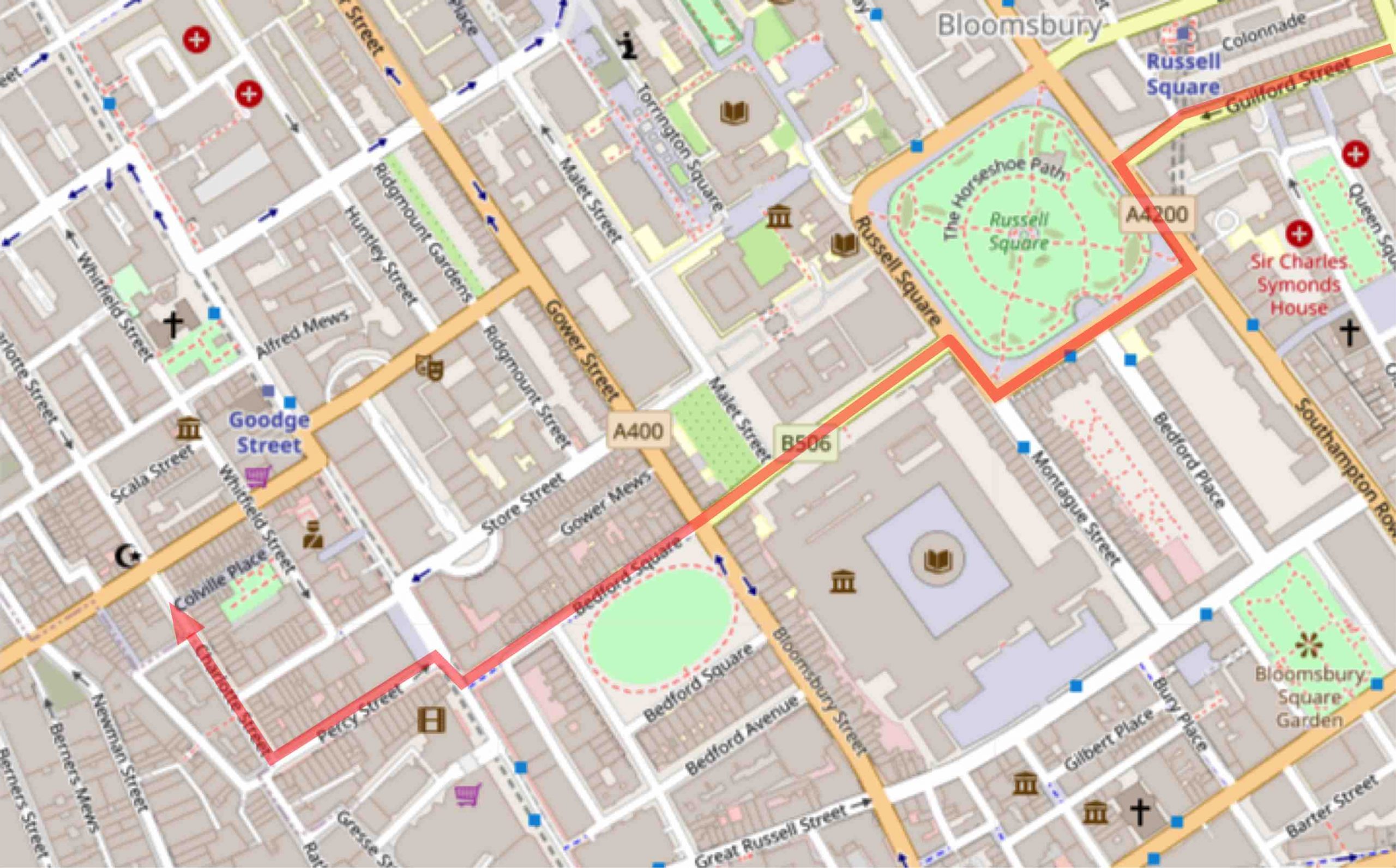
Endell Street – the key to new routes

The map shows with a blue line that Endell Street links the new route on Gower Street–Bloomsbury Way with the Q1 route to Waterloo Bridge. This provides a straight route which is far preferable to the old route (southbound via Bury Place, Newton Street and Great Queen Street and northbound via Drury Lane).


Endell Street runs between High Holborn and Long Acre, and the section north of Betterton Street is one-way southbound for motor vehicles. Two-way cycling has been enabled through this section.
Taking a northbound journey through Endell Street: on arrival at High Holborn there is a choice of “left-right” for the blue route up Bloomsbury Way and Gower Street or “right-left” for a new way to Bloomsbury via the pink route. See photos 19 and 20.
Grape Street – Coptic Street (the “right-left” pink route)
This provides a two-way cycling route from High Holborn via Grape Street, the top end of the closed section of Shaftesbury Avenue and Coptic Street to the British Museum.
Note: A short section of High Holborn between Shaftesbury Avenue and Museum Street is now two-way for all traffic.
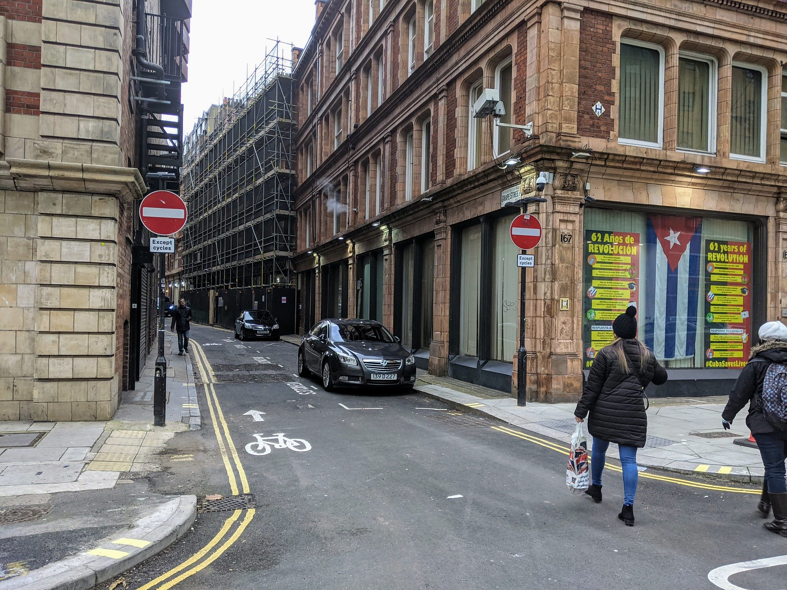

Photo 21 shows the entry to Grape Street with contraflow cycling and photo 22 shows the top of Shaftesbury Avenue. On enlargement, the sign shows ‘straight on’ for Bloomsbury and the British Museum and ‘right’ for Clerkenwell. (That would be via Bloomsbury Way and Theobalds Road)


Does the pink route work southbound?
We were unable to discover any signage for the southbound route. From Great Russell Street, turn left into Coptic Street and follow the above route in the reverse direction using the cycle crossing over new Oxford Street into the top end of Shaftesbury Avenue and then Grape Street.


And the rest
Huntley Street
Two-way cycling has been enabled between Chenies Street and Torrington Place. Pity we can’t have the section north of Torrington Place!


Chenies Street between Gower Street and Alfred Place

Store Street


This adds to the existing contraflow at the western end of Store Street to provide two-way cycling through its entire length.
Richbell Place


Richbell Place is a short road running east from Lamb’s Conduit Street behind Holborn Police Station.
College Place – southern end
College Place runs parallel to Royal College Street and can already be accessed from Plender Street and Pratt Street. But for someone approaching from the south, immediate access to the southern section is going to be useful.


Fleet Road and Cressy Road
Cressy Road
Cressy Road is one-way northbound from the ambulance station. People have been asking to be able to cycle south through Cressy Road ever since 2010 so that they can avoid being diverted round the Fleet Road gyratory.


Fleet Road contraflow between Cressy Road and Lawn Road

This contraflow lane allows people cycling south on Cressy Road to continue their journey down Lawn Road.
This was a good thing to come out of the frustrating attempts to tame Fleet Road.
Closing comments
The Covid-19 Streetspace funding, together with the completion of the West End Project has produced a bumper crop of permeability measures.
We reported on the first five Streetspace schemes in 2020 here and one on St Augustine’s Road here. Of the schemes described above seven were completed by December 2020. The remaining nine have been completed this year (2021).
West End Project
The long-awaited extension of Gower Street– Bloomsbury Way via Endell Street has made a vast improvement to the route to Waterloo Bridge. And the alternative connection via Grape Street is a clever addition.
Permeability promises
The West End Project officer’s report Appendix D said:
6. Cycling
An additional fifteen streets would allow cycling in both directions to improve routes through the area and encourage people to cycle, including Gower Place, Gower Street/Bloomsbury Street, Grafton Way, Huntley Street, Warren Street, Tottenham Street, Store Street, Chenies Street, Ridgmount Gardens, Bedford Avenue, Bedford Square, Endell Street, Tottenham Court Road, High Holborn (part) and Shaftesbury Avenue.
We are therefore disappointed not to have two-way cycling in the following streets:
- Gower Place and Ridgmount Gardens. Gower Place is particularly important as part of a connection to UCLH that avoids Euston Road. (Endsleigh Gardens has had two-way cycling since 2011.)
- The eastern ends of Grafton Way and Warren Street.
- The western end of Chenies Street;
- the northern end of Huntley Street.
and we remain hopeful that Camden may find it possible to complete Tottenham Street.
The “SSL Relief route” – a bit of history
This is another example of how two-way cycling on Gower Street and TCR helps with east-west routes.
In 2008 when the two-way track on Tavistock Place was already getting too crowded, CCC proposed a ‘Relief Route’. In those days, the Tavistock Place route was part of the Seven Stations Link (SSL).
Implement a parallel 'relief route' south of the SSL. E.g along Windmill Street, Store Street, Keppel Street, Montague Place, Russell Square, Guilford Street. This would link with Route 0 at the Islington border in Calthorpe Street. It might rejoin Route 0 in Wigmore Street. This would be a permeability exercise - based mainly on the introduction of contraflow cycling. Dave pointed out that 2-way in Tottenham Court Road and Gower Street would be helpful in this idea.
Work on contraflows was implemented in Percy Street, Bayley Street, Bedford Square (north side) and Montague Place as part of Cycle Hire Complementary Measures in 2010-11. Also in 2011, Russell Square was made two-way. This route only worked in a westbound direction across Tottenham Court Road until April 2019 when Tottenham Court Road was made two-way for buses and cycles.
Although this route has never been signed, it is direct and useful, and apart from the Guilford Street one-way system uses the same streets in both directions.
Fitzrovia – getting around by bike
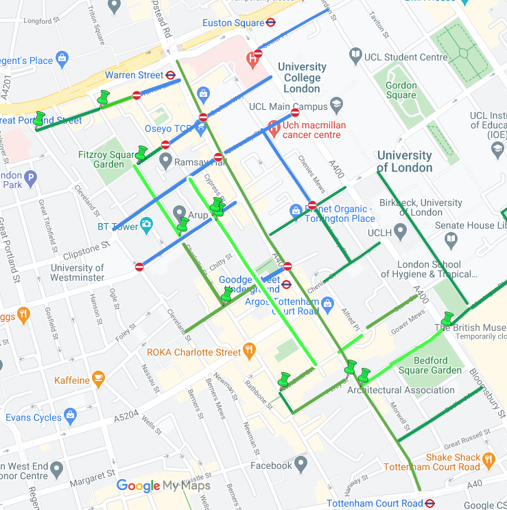
Tottenham Court Road forms a barrier between the areas on either side. Comparing these two maps, it can be seen that the recent changes have made a big contribution to permeability within the area west of TCR but that the opportunities for getting in and out of that area are still limited. And there are opportunities for lightweight schemes on Warren Street and Tottenham Street.
Howland Street and Maple Street are interesting: they have more motor traffic as well as the extension of the cycle route on Tavistock Place route on segregated lanes. We look forward to seeing an LTN in this area which will reduce the motor traffic on these two roads enabling them to become two-way for cycling.