
News from the Streets Sept 2025
News from the Streets May 2025
News from the Streets Sept 2024
News from the Streets May 2024
News from the Streets March 2024
News from the Streets February 2024
Click on any image to see an enlargement
Progress on major projects under construction
Grays Inn Road scheme upgrade completed
This is an interesting scheme. It was planned and then consulted on late in 2019 and was expected to follow the schemes in Pancras Road and Midland Road in using stepped tracks but due to a shortage of funding Camden used light segregation (orcas or flexible bollards) for most of the way with stepped tracks on the narrower sections opposite bus stop bypasses and kerb segregation on approaches to junctions.
Importantly, it included junction upgrades at both Sidmouth Street/Ampton Street and Guilford Street/Calthorpe Street providing a dedicated signal for cycles on the C27/C6 route at the former and on Gray’s Inn Road at the latter. The junction at Theobalds Road was not upgraded but we expect this to happen soon as part of the Clerkenwell Road scheme.
It also included five new bus stop bypasses and four parallel crossings.
This report from December 2021 describes all of the above features, which were by then completed. However Camden decided in 2022 to ‘make it permanent’ by replacing the light segregation (flexible bollards) by kerbs and to add rain gardens round the bus stop bypass islands and add a fifth parallel crossing. This work was completed in Summer 2025.
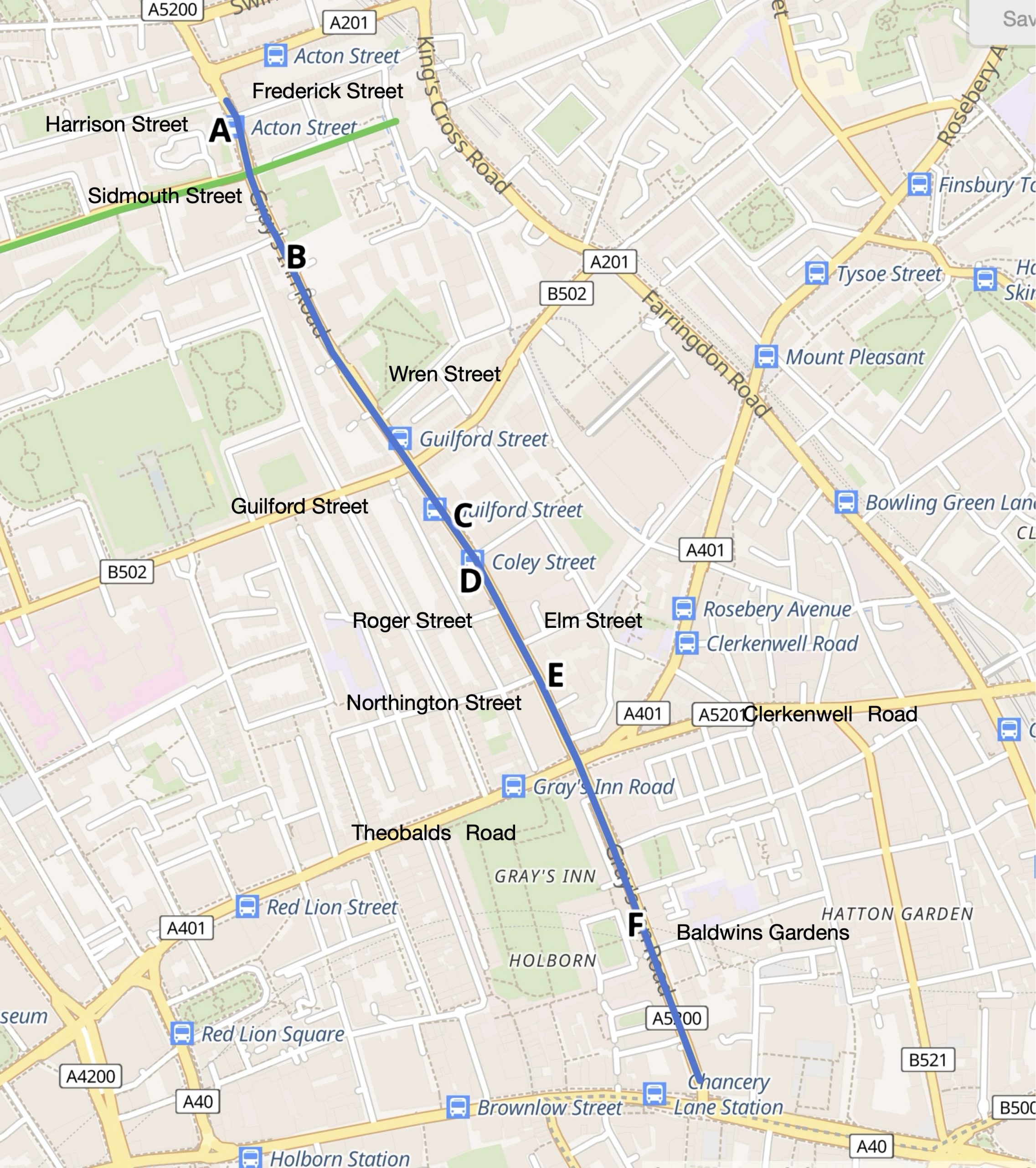
Although the rain gardens have not yet been planted, it is easy to imagine that they will truly transform Gray’s Inn Road; and it’s not just at the end of bus stops! They also appear in the middle of a parallel crossing. Here are a few photos taken during a walk down from the start of the route just north of Sidmouth Street junction almost to High Holborn. The sites are labelled A-F and their locations are shown on the above map. The two permeability gains will be left for another report.
A. The Bus Stop Bypass north of Sidmouth Street
This BSB (Bus Stop Bypass ) which is situated on the west side of GIR (Grays Inn Road) a little north of Sidmouth Street is the first of the original BSBs. It has plots for rain gardens at both ends and a space for cycle parking. The photo on the left shows the blue painted lane crossing the junction with Harrison Street. Beyond that is the bus shelter on the island, some cycle parking stands and then another strip for a rain garden – you can enlarge the photos to see more detail by clicking on them.


B. The New Parallel Crossing north of Wren Street
Travelling south down the west side of GIR, we see a short rain garden plot, then the crossing and then a much longer rain garden plot. The grass in these plots hints that they are going to look lovely once they have been planted.


C. The Bus Stop Bypass on the east side of GIR north of Coley Street
To understand these photos, think of walking down the east side of GIR, crossing Calthorpe Street at the signals and continuing to Coley Street; and then turning round to face north. This bus stop island has been extended almost to the junction with Coley Street to provide a small plot for a rain garden. Then moving north beside the bypass, the second photo shows the cycle stands and beyond that a long rain garden plot. We understand that the boulders in the rain gardens are there to discourage drivers from trying to park there.


D. Bus stop bypass on the west side of GIR opposite Coley Street
This bus stop bypass starts opposite the front of the previous one (C). The first photo shows someone cycling up inside the island with Coley Street visible on the other side of GIR. The second photo is facing the other way (looking south), showing the new rain garden (with three new trees and some grass) that extends as far as the parallel crossing that’s just north of the junction with Roger Street.


E. Bus stop bypass on the east side of GIR opposite Northington Street
Imagine using the parallel crossing by Roger Street to cross over GIR, and then continuing southbound as far as Elm Street. There’s another parallel crossing south of this junction. The photo on the left below shows the rain garden plot starting immediately after the Elm Street crossing. It is interrupted by a group of bike stands and then stretches as far as the junction with Northington Street across the road where there’s a cycle gap. The bus stop island is beyond the cycle gap.


F. Bus stop bypass on the west side of GIR north of the zebra crossing by Baldwins Gardens
To get to this BSB you could continue down the east side of GIR, wait for the signal at the Theobalds Road – Clerkenwell Road junction and then continue down GIR as far as Baldwins Gardens where there is a zebra crossing. This crossing can be used to reach the west side of GIR. The photo on the left below shows a view of the zebra crossing with a rain garden plot stretching away behind it.


Finishing touches and smaller projects
The junction at York Way – Market Road
This junction has been through some changes. Before the York Way trial cycle lanes were installed in 2020 there was a roundabout and vehicular cycling was required to make the right turn from Market Road into York Way. Then there was just a Give Way at the junction with York Way and a gap between the flexible wands opposite for getting into the northbound cycle lane. Making the right turn into Market Road was to say the least, tricky! See this image from StreetView dated July 2024.
The junction has now been redesigned to make all the turns safer and protected from motor vehicles using parallel crossings (zebras with associated cycle crossings).

It is important to understand that both parallel crossings are (as usual) two way and so is the cycle track round the northeast corner of the junction that joins the two crossings.
The drawing extract on the right shows the movement for the right turn out of Market Road in red and the right turn into Market Road in blue. After spending some time at the junction some of the users were observed doing strange things to achieve these right turns e.g. one person rode out of Market Road across York Way and then dragged their bike across the rain garden on the far side. Perhaps it could help to have a sign illustrating the movement on the approach to the junction ?
Most users travelling south on York Way across the junction did seem willing to make the slight diversion into Market Road and use the crossing.
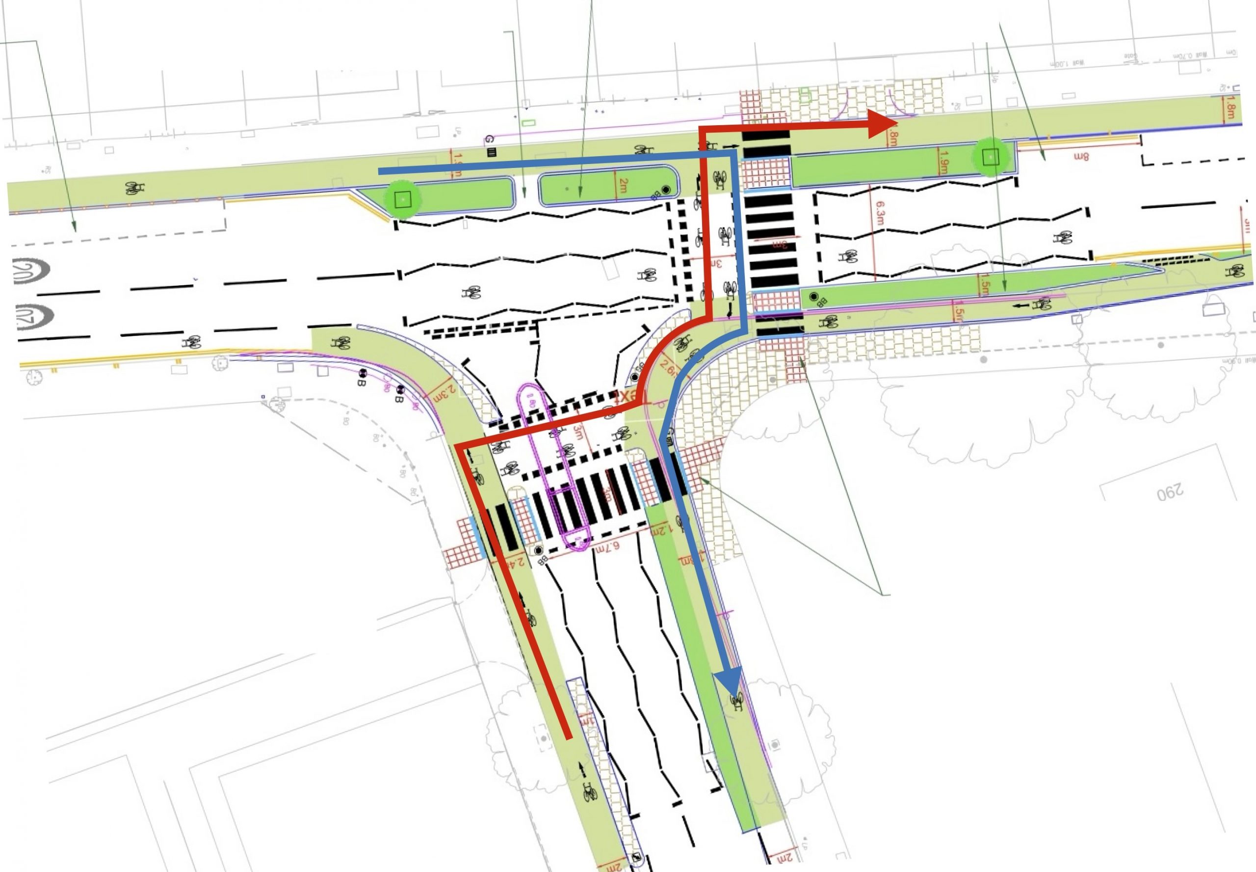
As can be seen from the photograph above, the whole junction looks very attractive – it is pleasing to see how rain gardens can fit into many different designs. If used ‘correctly’ (as the designers intended) all of the six available cycle movements through the junction can be carried out without conflict from motor vehicles. The only negative factor is that after turning left from Market Road the cycle lane is advisory. Let’s hope that Islington Council will fix this soon.
12 Permeability gains during 2025
During 2025 Camden has implemented two-way cycling in 11 one-way streets and improved one cycle gap. We wrote about the Camden Street contraflow between Bonny Street and Camden Gardens in the September issue; and about Leather Lane in the May issue. (2)
In the next issue of News from the Streets we plan to write about the making permanent of the cycle lanes in St Pancras Way: a scheme that also includes the implementation of a segregated contraflow cycle lane in Pratt Street east of Royal College Street. (1)


We plan to describe the Bucknall Street area scheme; and the above permeability schemes in the next issue of News From the Streets..


Five new point closures in 2025
We wrote about the closure of Willes Road at the junction of Inkerman Road (with a bollard and planters) in the September issue and the closure of Camden High Street (north) at Britannia junction in our May issue. (2)


Rain Gardens in Bayham Street
Spotted after getting off a bus in Baynes Street. A part of the Crowndale Road scheme so far unspotted; and this rain garden has been planted!

