
In April 2019 Camden Council published their Transport Strategy 2019-2041 which includes a Cycling Action Plan with maps showing their planning for the growth of a cycle network by 2025 and by 2041. This was followed by regular updates with maps showing progress and upcoming plans. The 2025 map which we discuss here is the first to show proposed junction improvements.. Click on any image to enlarge it.

Camden’s map in Fig 1 from the Camden Transport Strategy Annual Update (2025) shows a set of links that when combined make up the Cycle Network in Camden. The solid lines form the Cycle Network as it now is while the dashed lines show plans for how it could be by 2028. The circles show the junctions where improvements are planned.
Almost all of the purple links are on main roads1(which generally provide the most direct routes) and have protected cycle lanes2; while the blue links are on low-traffic roads where it is safe for cycles to mix with motor traffic.
1 The C50 route through Camden Square is mostly on low-traffic roads.
2 In Tottenham Court Road cycles share the road with buses (and in the evenings and on Sundays with general motor traffic)
As can be seen from the map, Camden has a policy of extending the network in a way that keeps it joined up. The two exceptions (the link on Spaniards Road and the zig-zag link parallel to Finchley Road date from 2007 and earlier).
The links
All of the protected links have either stepped tracks, or cycle lanes protected by kerbs.
The low-traffic (blue) links are on roads where it is safe for cycles to mix with motor traffic. LTN 1/20 suggests a definition of Low traffic flow as less than 2500 motor vehicles per day and HGV and bus flow < 250 per day. Another criterion is <200 motor vehicles in peak hours with <5% buses or lorries.
We have made this map to record progress in developing the Cycle Network. The links with protected lanes are in purple and their total length is just over 25km. We show the low traffic links that we consider suitable for shared use in orange (about 55 km of which almost 40 are signed) and the other ‘proposed links’ in yellow. For example, Elsworthy Road (on Camden’s map) requires filtering to make it suitable for shared use.
The network nodes
These are the junctions where the links meet. In Figure 1, Camden has singled out a few of them where they plan to make improvements. These include York Way – Agar Grove and Gray’s Inn Road – Clerkenwell Road – Theobalds Road which have been consulted on recently. However, almost every new link has been accompanied by one or more improved junctions. Recent examples of signalised junctions include Chalk Farm Road – Crogsland Road – Adelaide Road and Prince of Wales Road – Grafton Road- Castlehaven Road; and five improved junctions in Tavistock Place. Two recently improved junctions on York Way deploy parallel crossings to protect all movements – at Market Road and at Randell’s Road – Beaconsfield Street. Many other junctions at side roads have new continuous footways and Dutch kerbs. It would be hard to include all of these on Camden’s map; perhaps the signalised ones could be. Anyway, it would be good to see a graphical representation of all these improvements.
The distance between the links
Figure 2 shows a copy of the links in the south of the borough over an approximately 400m grid. This shows that residents in this area mostly live within 200m of a north-south cycle link – the only bigger gap is between the Red Lion and the Montague Street alignments which is 500-600m.
Currently the only borough-wide east-west alignment is along Tavistock Place. The situation was better during the short period in 2020 – 2022 when Euston Road had cycle lanes.
Work has just started on building protected cycle lanes on Clerkenwell Road and Shaftesbury Avenue (pink dashes) and Theobalds Road – Bloomsbury Way (green dashes) should follow, resulting in an east-west link about 800m south of Tavistock Place. The intermediate link (on Guilford St) is planned on the same timescale.
Figure 3 shows a copy of the links in the north of the borough over an approximately 500m grid. The distance between Royal College Street (RCS) and Arlington Road is ~500m, while Albany Street is almost 500m west of Arlington Road. York Way is ~800m east of RCS, but there is an intermediate link (on Camley Street – Pancras Road). Starting from Euston Road, the RCS protected (purple) link is roughly on gridline 2 until it turns left onto Prince of Wales Road and then right up Haverstock Hill (on grid line 4). The Grafton Road (blue) link continues roughly on gridline 2, while the proposed (green dash, Malden Road) link is roughly on gridline 3.
The continuation of Arlington Road on Hampstead Road needs an upgrade. The HS2 work around Euston Station has disrupted a useful link on Cardington Street – Melton Street, which would connect to the link on Gordon Street.
Once the green dash links on Highgate Road and Fortess Road – Dartmouth Park Hill (and Malden Road) are built there will be links roughly following grid lines 1 to 4 between Euston Road and line f. So residents of this area will live within 250m of a network link. BUT the grid has to have east-west links as well!
The link on Goodsway follows gridline a (~900m north of Tavistock Place – see Figure 2); this continues on Phoenix Place (blue line) then Euston Station (shown as a grey area) blocks gridline a. On the west side of Euston Station a link on Robert Street would be worth considering.
The Cross Camden Cycleway (CCC) southern branch is soon to be consulted on. See the green dash link on Prince Albert Road and then Delancey – Pratt. It runs between gridline c and gridline b as far as RCS. A variety of blue and purple links continue eastbound via Camden Square to the Camden – Islington boundary
The links on Elsworthy Road – King Henry’s Road and Prince of Wales Road follow gridline d; with a possible continued link via Angler’s Lane and Gaisford Road. The northern branch of the CCC will extend the King Henry’s Road link via Chalk Farm Road then east across Kentish Town Road via Wilmot Place and Rochester Road to Camden Square close to gridline c.
There are no links on gridline e. The green dash links from Mansfield Road to Belsize Road are close to gridline f.

LTN 1/20 under the Cycling Level of Service Tool: “the ultimate aim should be a network with a mesh width of 250m”. However, in this area the natural mesh width is ~400m (the width of the gap between Judd Street– Hunter Street and Gray’s Inn Road).

The natural mesh width between Euston Road and Hampstead Heath is ~500m (the width of the gap between Arlington Road and Royal College Street). But the mesh height may need to be bigger e.g. with alignments on grid lines a (partial), b-c, d and f.
The 2019 cycling action plan gave targets (48% by 2024 and 93% by 2041) for the percentage of Borough residents within 400m of a London-wide strategic cycle network. This target originated from the Mayor’s Transport Strategy (2018) which said: “By 2041, 70 per cent of Londoners will live within 400 metres of the strategic cycle network”
From CTS update: “by 2024, 61% of our residents were within 400m of a strategic cycle network route, on track towards our 2030 target (70%)”.
It was only when making these maps that we realised that these targets can be met with parallel alignments in one direction only rather than a true grid!
Cycle Routes
Each of the cycle routes in Camden follows a sequence of links (with protected cycle lanes or on low-traffic roads) through the Camden Cycle Network and passes through a few destinations. Some of the routes that reach the borough boundary continue to destinations outside Camden. We illustrate how this works with examples related to Cycleway 6 (C6 on the signs) that currently runs from Haverstock Hill to Elephant and Castle.
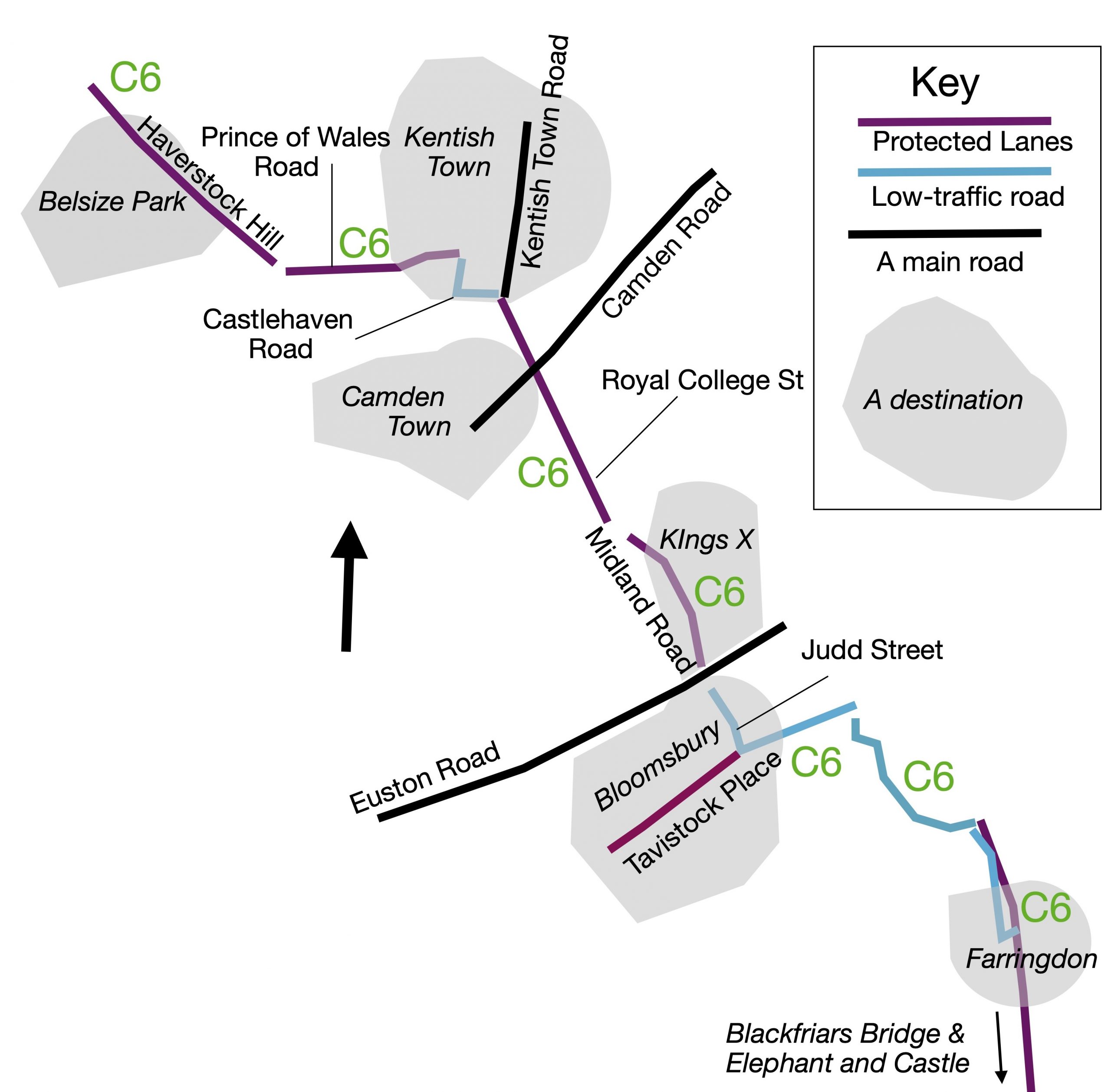


The destinations on C6 include Belsize Park, Kentish Town, Camden Town, Kings Cross, Bloomsbury and Farringdon. See Figure 4. They also include Blackfriars Bridge and Elephant and Castle. These destinations and other smaller ones are shown on the signs.
The links comprising C6: Haverstock Hill*, Prince of Wales Road, Royal College Street, Pancras Road and Midland Road are on main roads and have protected cycle lanes. The blue link on Castlehaven and Castle Roads is a short cut that avoids a junction and a short length of Kentish Town Road.
* still being upgraded from wands
The section of C6 between Judd Street and Farringdon Road is on low-traffic roads. When the crossing over Euston Road was designed, Camden decided to close Judd Street at Euston Road, thus converting it (in 2019) from a main road into a low-traffic road.
TfL (Transport for London) is responsible for naming routes (i.e. selecting alignments and assigning numbers such as C6; some shorter routes are just labelled as C-links). See this map on TfL’s website to learn more about the routes.
Figure 5 shows a ‘C-link’ route on Grafton Road that is signed to Hampstead Heath. In 2021, an LTN in the Queen’s Crescent area removed through traffic from Grafton Road so that it became a low-traffic road.
TfL’s signs show the route name (e.g. C6), the next destination and an estimate of the time to cycle there. The sign on the right is on Grafton Road approaching Prince of Wales Road. Heading straight ahead on C6 via Royal College Street will take you to St Pancras International (on Midland Road) in 13 minutes. Turning right on C6 via Prince of Wales Road will take you to Hampstead. (It might have been better to make this destination Belsize Park (see Figure 4)). Turning left gets you to Kentish Town via Angler’s Lane in 2 minutes.

The cycle network map shows other blue links, many of which are for linking one route to another.
Figure 6 shows some examples
- A link on Queen’s Crescent that would provide a short cut from Prince of Wales Road to Grafton Road for anyone heading to Hampstead Heath.
- A link Harmood Street between Prince of Wales Road and Chalk Farm Road
- A link on Crogsland Road between Prince of Wales Road and Chalk Farm Road; this link continues west towards Primrose Hill via King Henry’s Road.
These blue links that are shown on Camden’s Map (Figure 1) are on low-traffic roads and safe crossings should be provided where they cross main roads. For example, the crossing of Queens Crescent over Malden Road (green dashes in Camden’s Map) needs improvement.
Note also that TfL has made a good map of the cycle routes in Camden