

News from the Streets Dec 2025
News from the Streets Sept 2025
News from the Streets May 2025
News from the Streets Sept 2024
News from the Streets May 2024
News from the Streets March 2024
Click on any image to see an enlargement
Progress on major projects under construction
Haverstock Hill scheme upgrade completed
The Haverstock Hill cycle link runs for just over a kilometer between Prince of Wales Road and Pond Street. The trial scheme with wand-protected cycle tracks was completed in 2022. The permanent scheme is now virtually complete.
The cycle lanes are implemented as stepped tracks from Belsize Avenue (near the north end of the scheme) almost down to Englands Lane; and at the southern end from Steele’s Road onwards. In between, the lanes are mainly protected by kerbs.
On the northbound side, the trial scheme included three SUBBs (shared use bus boarders); two of these have now been replaced by Bus Stop Bypasses. But as in the trial scheme, all the bus stops on the southbound side are ‘in line bus stops’ (if a bus is present cyclists can either wait or ride round the bus. See this photo.). We don’t like this decision but Camden says that on a steep down hill, the alternatives are unsafe. See here for a map of bus stops on cycle routes in Camden.

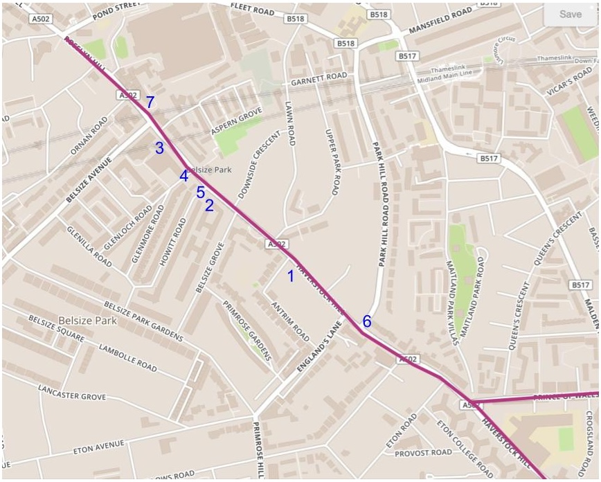
The map on the right shows the location of the photos in this post.
- Joy of cycling at junction with Antrim Grove
- Floating parking between Belsize Grove and Howitt Road
- Floating parking and bus stop bypass near the Cinema
- Side road junction at Glenloch Road
- Side road junction at Howitt Road
- Side road junction at Parkhill Road
- Side road junction outide Rosary RC Primary School
Note: the northbound stepped track ends at Belsize Avenue after which northbound cyclists use a bus lane; the southbound stepped track starts a little north of number 7. The distance between Pond Street and Prince of Wales Road is about 1.2 km but we estimate the length of the protected lanes to be just over a kilometer.
Floating parking : On the west (uphill) side of Haverstock Hill opposite Belsize Park station where the footways are very wide, some of the width has been used to provide two strips of floating parking and to accommodate a bus stop bypass.
Boundary between cycle track and footway, The examples in photos 2 and 3 show a very attractive approach to making a visible boundary between the cycle track and the footway by using a distinctive type of kerb. In Camden’s earlier schemes, e.g. Prince of Wales Road eastbound, the footway was bounded by the usual kerb and the cycle track was lower and coloured black. This style of separator has been used in other recent schemes e.g. on St Pancras Way, on Chalk Farm Road and on York Way but this is the first time that we have commented on it. We definitely approve: apologies for being so slow to comment.


Side Road junctions. Almost all of these junctions now have a continuous footway to the left of the cycle track and a ‘Dutch kerb’ on the right.
A so-called Dutch kerb is an entrance block that allows safe vehicular crossing over the cycle carriageway when accessing side roads and even entrances to buildings, from main roads where drivers need to cross cycle lanes and footways. Drivers have to negotiate the change in level, thus slowing traffic speed and making it safer and easier for people travelling on foot and by bicycle in the very busy streets we have in Camden.
The first Dutch kerb we saw in Camden was in Bloomsbury Way (2023), soon followed by one on Prince of Wales Road. A year later (2024) a few appeared in York Way and one in Red Lion Square. Then last summer we saw one on the C50. They work perfectly with stepped tracks which are at footway level (see photos 4 and 5 below). In photo 7, the cycle lane changes to stepped track before passing Parkhill Road and reverts to kerb protection soon after; photo 1 shows the kerb protection after the junction.


Conclusions: Camden is to be congratulated on completing this scheme to a very high standard. After 10 years experience in laying stepped tracks (see the first in Pancras Road) they seem to have brought it to a fine art. As mentioned above we like the use of the decorative kerb separators with cycle track and footway at the same level. Another magnificent feat is the building of all those junctions with continuous footway and Dutch kerbs. We have photos of 11 Dutch kerbs including a couple outside buildings. We are also pleased to see the implementation of the imaginative use of floating parking with the inclusion of a bus stop bypass. However there are still too many interruptions on the southbound side with the inline bus stops and loading – we are working on a detailed audit.
Cycle counts: there are two counters on Haverstock Hill; in our report on the trial scheme we gave mid-week (Tue-Thur) counts of around 1000 a day at a count point just south of England’s Lane; and 600-700 a day at a point close to Belsize Park station. from mid-September 2022 In early July 2026 the figures were around 2300 and 1800.
The disappearance of the flexible wands. These were so very useful when the Streetspace for London provided funding for new temporary protected cycle lanes during the pandemic. And Camden grasped the opportunity, building over 13 kms of trial lanes in 2020-2022. Although effective, they have gradually been knocked down or otherwise damaged. The task of replacing them is almost done with the completion of Haverstock Hill – the only vestige we are aware of is at the southern end of St Pancras Way where there is ongoing construction work.
Finishing touches and smaller projects
Prince of Wales Road
The permanent scheme for the eastbound side was completed late in 2023. Recently Camden has fixed a few remaining loose ends:
Side Road junctions on the eastbound cycle track. The whole length of the eastbound track is implemented as stepped tracks: so it fits well with Dutch kerbs. As continuous footways had already been implemented at Talacre Road and Ryland Road as part of the westbound scheme, these were not upgraded when the trial eastbound scheme was made permanent.
Originally we wrote: But three years later Dutch kerbs had become part of Camden’s design toolkit. But after reports from users about discomfort e.g. on crossing into Ryland Road from the westbound cycle lane we note that the gradient of these kerbs is much steeper than at the junctions mentioned above. So now we ask: Why make this change?


Finishing touches to the junction at Grafton Road/Castlehaven Road. The drawings for the final scheme included a design for this junction but the work was held up due to delay in installing signals (!). On the east-west alignment cyclists are provided with a dedicated signal stage. These signals have been working since Spring 2025. The upgrade at Angler’s Lane approach to allow cycles to turn right into Prince of Wales Road appeared in May 2025. The signals on the Grafton Road (northern) approach and the Castlehaven Road (southern) approach provide green one after the other (as before) to allow essential right turn exceptions for cyclists.


The upgrade also included track levelling at several locations which has provided a much smoother ride.
Bucknall Street area improvements
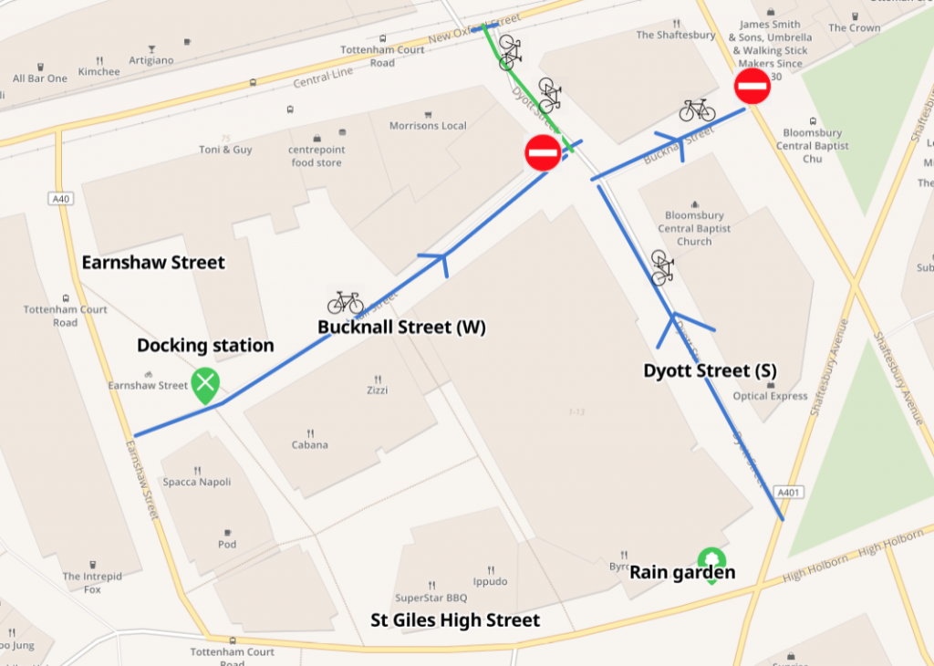
This scheme was completed last Autumn. It concerns a small area between New Oxford Street and St Giles High Street. The result is total cycling permeabiltiy through this area.
Bucknall Street is recognisable by the very tall colourful buildings. The western end has been made one-way eastbound with contraflow cycling; and two-way cycling has been introduced at the eastern end which was already one way.
Dyott Street was already closed to motor traffic at New Oxford Street. The new closure at the junction with Bucknall Street provides a new cycle only section. Two-way cycling has been introduced in the southern end which was already one way.
Bucknall Street


Dyott Street


Somers Town mobility hub in Charrington Street
Camden is rolling out a number of mobility hubs, initially in Somers Town and Kentish Town. These provide a mix of sustainable and active shared mobility modes, which can include shared bikes, car clubs, cargo bikes and e-scooters. They can also include other community features such as cycle parking, seating and planting or play areas, water fountains and other amenities designed to improve public space for residents and visitors. The one in Charrington Street includes a bike workstand, tools and a pump.

